Weather Alerts for Alaska
1. Flood Warning for: Central Brooks Range; South Slopes Of The Central Brooks Range; Upper Koyukuk Valley; Dalton Highway Summits
2. Flood Warning for: South Slopes Of The Central Brooks Range
3. Flood Watch for: Kuskokwim Valley West; Kuskokwim Valley East; Interior Kuskokwim Delta; Western Capes; Northern Bristol Bay Coast; Inland Bristol Bay
4. Flood Watch for: South Slopes Of The Central Brooks Range; South Slopes of the Western Brooks Range; Upper Kobuk Valleys
5. Heat Advisory for: Prince of Wales Island; Ketchikan Gateway Borough; City of Hyder; Annette Island
6. Hydrologic Outlook for: Anchorage; Anchorage Hillside / Eagle River; East Turnagain Arm; Portage; Lower Matanuska Valley; Hatcher Pass; Sutton / Upper Matanuska Valley; Eureka / Tahneta Pass; Southern Kachemak Bay; SW Kenai Peninsula; NW Kenai Peninsula; Skilak Lake; Southern Kenai Mtns; Interior Kenai Peninsula; Turnagain Pass; West Prince William Sound & Whittier; Tyonek; Valdez; Thompson Pass; Cordova; Western Susitna Valley; Southern Susitna Valley; Central Susitna Valley; Northern Susitna Valley
7. Hydrologic Outlook for: Kuskokwim Valley West; Kuskokwim Valley East; Interior Kuskokwim Delta; Western Capes; Northern Bristol Bay Coast; Inland Bristol Bay
8. Wind Advisory for: Eastern Alaska Range North of Trims Camp; Eastern Alaska Range South of Trims Camp
9. Winter Storm Warning for: Central Arctic Plains; Central Brooks Range
10. Winter Storm Watch for: Western Arctic Plains; Howard Pass and the Delong Mountains
11. Winter Weather Advisory for: Central Beaufort Sea Coast
Want more detail? Get the Complete 7 Day and Night Detailed Forecast!
Current U.S. National Radar--Current
The Current National Weather Radar is shown below with a UTC Time (subtract 5 hours from UTC to get Eastern Time).

National Weather Forecast--Current
The Current National Weather Forecast and National Weather Map are shown below.

National Weather Forecast for Tomorrow
Tomorrow National Weather Forecast and Tomorrow National Weather Map are show below.

North America Water Vapor (Moisture)
This map shows recent moisture content over North America. Bright and colored areas show high moisture (ie, clouds); brown indicates very little moisture present; black indicates no moisture.

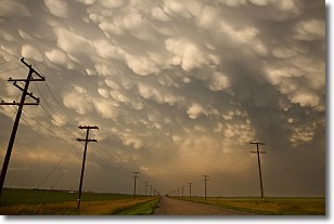
Weather Topic: What are Mammatus Clouds?
Home - Education - Cloud Types - Mammatus Clouds
 Next Topic: Nimbostratus Clouds
A mammatus cloud is a cloud with a unique feature which resembles
a web of pouches hanging along the base of the cloud.
In the United States, mammatus clouds tend to form in the warmer months, commonly
in the Midwest and eastern regions.
While they usually form at the bottom of a cumulonimbis cloud, they can also form
under altostratus, altocumulus, stratocumulus, and cirrus clouds. Mammatus clouds
warn that severe weather is close.
Next Topic: Nimbostratus Clouds
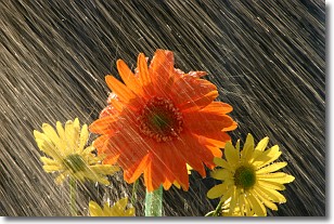
Weather Topic: What is Precipitation?
Home - Education - Precipitation - Precipitation
 Next Topic: Rain
Precipitation can refer to many different forms of water that
may fall from clouds. Precipitation occurs after a cloud has become saturated to
the point where its water particles are more dense than the air below the cloud.
In most cases, precipitation will reach the ground, but it is not uncommon for
precipitation to evaporate before it reaches the earth's surface.
When precipitation evaporates before it contacts the ground it is called Virga.
Graupel, hail, sleet, rain, drizzle, and snow are forms of precipitation, but fog
and mist are not considered precipitation because the water vapor which
constitutes them isn't dense enough to fall to the ground.
Next Topic: Rain
Current conditions powered by WeatherAPI.com


