Weather Alerts for California
1. Extreme Heat Warning for: Coalinga - Avenal; Fresno-Clovis; West Side Mountains South of 198; Buena Vista; Bakersfield; South End San Joaquin Valley; Fresno-Tulare Foothills; South End Sierra Foothills
2. Extreme Heat Warning for: Cuyama Valley; Santa Clarita Valley; Santa Lucia Mountains; Southern Salinas Valley; San Luis Obispo County Interior Valleys; San Luis Obispo County Mountains; Santa Ynez Valley; Santa Barbara County Interior Mountains; Western Santa Monica Mountains Recreational Area; Calabasas and Agoura Hills; Western San Fernando Valley; Eastern San Fernando Valley; Southeastern Ventura County Valleys; Santa Susana Mountains; Southern Ventura County Mountains; Northern Ventura County Mountains; Interstate 5 Corridor; Western San Gabriel Mountains and Highway 14 Corridor; Eastern San Gabriel Mountains; Western Antelope Valley Foothills; Eastern Antelope Valley Foothills; Antelope Valley; Los Angeles County San Gabriel Valley
3. Extreme Heat Warning for: Santa Ynez Mountains Western Range; Santa Ynez Mountains Eastern Range; Los Angeles County Inland Coast including Downtown Los Angeles; Eastern Santa Monica Mountains Recreational Area
4. Extreme Heat Warning for: Western Siskiyou County; Central Siskiyou County
5. Flood Watch for: Greater Lake Tahoe Area; Greater Lake Tahoe Area; Greater Reno-Carson City-Minden Area; Northern Washoe County
6. Flood Watch for: Mono; Mineral and Southern Lyon Counties
7. Flood Watch for: Yosemite NP outside of the valley; Upper San Joaquin River; Kaiser to Rodgers Ridge; Kings Canyon NP
8. Heat Advisory for: Lake Casitas; Ojai Valley; Central Ventura County Valleys
9. Heat Advisory for: West Side of Fresno and Kings Counties; Caruthers - San Joaquin - Selma; Buttonwillow - Lost Hills - I5; Delano-Wasco-Shafter; Hanford - Corcoran - Lemoore; Visalia - Porterville - Reedley; Southeast San Joaquin Valley; Kern River Valley
10. Red Flag Warning for: Trinity
11. Red Flag Warning for: Western Klamath National Forest; Central Siskiyou County Including Shasta Valley; Siskiyou County from the Cascade Mountains East and South to Mt Shasta; Modoc County Except for the Surprise Valley; Siskiyou Mountains; Southern Oregon Cascades; Klamath Basin and the Fremont-Winema National Forest; South Central Oregon Desert including the BLM Land in Eastern Lake and Western Harney Counties
12. Special Weather Statement for: South End of the Upper Sierra
13. Special Weather Statement for: Western San Gabriel Mountains and Highway 14 Corridor; Eastern San Gabriel Mountains; Western Antelope Valley Foothills; Eastern Antelope Valley Foothills; Antelope Valley
14. Special Weather Statement for: Yosemite NP outside of the valley; Yosemite Valley; Upper San Joaquin River
Want more detail? Get the Complete 7 Day and Night Detailed Forecast!
Current U.S. National Radar--Current
The Current National Weather Radar is shown below with a UTC Time (subtract 5 hours from UTC to get Eastern Time).

National Weather Forecast--Current
The Current National Weather Forecast and National Weather Map are shown below.

National Weather Forecast for Tomorrow
Tomorrow National Weather Forecast and Tomorrow National Weather Map are show below.

North America Water Vapor (Moisture)
This map shows recent moisture content over North America. Bright and colored areas show high moisture (ie, clouds); brown indicates very little moisture present; black indicates no moisture.

Weather Topic: What is Precipitation?
Home - Education - Precipitation - Precipitation
 Next Topic: Rain
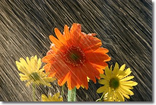
Precipitation can refer to many different forms of water that
may fall from clouds. Precipitation occurs after a cloud has become saturated to
the point where its water particles are more dense than the air below the cloud.
In most cases, precipitation will reach the ground, but it is not uncommon for
precipitation to evaporate before it reaches the earth's surface.
When precipitation evaporates before it contacts the ground it is called Virga.
Graupel, hail, sleet, rain, drizzle, and snow are forms of precipitation, but fog
and mist are not considered precipitation because the water vapor which
constitutes them isn't dense enough to fall to the ground.
Next Topic: Rain
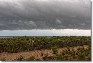
Weather Topic: What are Shelf Clouds?
Home - Education - Cloud Types - Shelf Clouds
 Next Topic: Sleet
A shelf cloud is similar to a wall cloud, but forms at the front
of a storm cloud, instead of at the rear, where wall clouds form.
A shelf cloud is caused by a series of events set into motion by the advancing
storm; first, cool air settles along the ground where precipitation has just fallen.
As the cool air is brought in, the warmer air is displaced, and rises above it,
because it is less dense. When the warmer air reaches the bottom of the storm cloud,
it begins to cool again, and the resulting condensation is a visible shelf cloud.
Next Topic: Sleet
Current conditions powered by WeatherAPI.com


