Weather Alerts for California
1. Beach Hazards Statement for: San Diego County Coastal Areas; Orange County Coastal
2. Extreme Heat Warning for: Coachella Valley
3. Extreme Heat Warning for: San Diego County Deserts
4. Extreme Heat Warning for: San Gorgonio Pass Near Banning
5. Extreme Heat Warning for: Santa Clarita Valley; Santa Lucia Mountains; San Luis Obispo County Mountains; Santa Ynez Mountains Western Range; Santa Ynez Mountains Eastern Range; Santa Barbara County Interior Mountains; Lake Casitas; Ojai Valley; Central Ventura County Valleys; Los Angeles County Inland Coast including Downtown Los Angeles; Western Santa Monica Mountains Recreational Area; Eastern Santa Monica Mountains Recreational Area; Calabasas and Agoura Hills; Western San Fernando Valley; Eastern San Fernando Valley; Southeastern Ventura County Valleys; Santa Susana Mountains; Southern Ventura County Mountains; Interstate 5 Corridor; Western San Gabriel Mountains and Highway 14 Corridor; Eastern San Gabriel Mountains; Los Angeles County San Gabriel Valley
6. Heat Advisory for: Catalina and Santa Barbara Islands; San Luis Obispo County Beaches; San Luis Obispo County Inland Central Coast; Santa Barbara County Central Coast Beaches; Santa Barbara County Inland Central Coast; Santa Ynez Valley; Santa Barbara County Southwestern Coast; Santa Barbara County Southeastern Coast; Ventura County Beaches; Ventura County Inland Coast; Malibu Coast; Los Angeles County Beaches; Palos Verdes Hills
7. Heat Advisory for: Orange County Coastal
8. Heat Advisory for: Orange County Inland
9. Heat Advisory for: Owens Valley; Esmeralda and Central Nye County; Lincoln County
10. Heat Advisory for: Riverside County Mountains
11. Heat Advisory for: San Bernardino and Riverside County Valleys-The Inland Empire
12. Heat Advisory for: San Bernardino County Mountains
13. Heat Advisory for: San Diego County Coastal Areas
14. Heat Advisory for: San Diego County Inland Valleys
15. Heat Advisory for: San Diego County Mountains
16. Heat Advisory for: San Francisco; Marin Coastal Range; Sonoma Coastal Range; North Bay Interior Mountains; Coastal North Bay Including Point Reyes National Seashore; North Bay Interior Valleys; San Francisco Bay Shoreline; San Francisco Peninsula Coast; East Bay Interior Valleys; Santa Cruz Mountains; Santa Clara Valley Including San Jose; Eastern Santa Clara Hills; East Bay Hills; Southern Salinas Valley/Arroyo Seco and Lake San Antonio; Santa Lucia Mountains and Los Padres National Forest; Mountains Of San Benito County And Interior Monterey County Including Pinnacles National Park; Northern Salinas Valley/Hollister Valley and Carmel Valley; Northern Monterey Bay; Southern Monterey Bay and Big Sur Coast
17. Heat Advisory for: San Miguel and Santa Rosa Islands; Santa Cruz and Anacapa Islands
18. Heat Advisory for: Santa Ana Mountains and Foothills
Want more detail? Get the Complete 7 Day and Night Detailed Forecast!
Current U.S. National Radar--Current
The Current National Weather Radar is shown below with a UTC Time (subtract 5 hours from UTC to get Eastern Time).

National Weather Forecast--Current
The Current National Weather Forecast and National Weather Map are shown below.

National Weather Forecast for Tomorrow
Tomorrow National Weather Forecast and Tomorrow National Weather Map are show below.

North America Water Vapor (Moisture)
This map shows recent moisture content over North America. Bright and colored areas show high moisture (ie, clouds); brown indicates very little moisture present; black indicates no moisture.

Weather Topic: What are Cirrus Clouds?
Home - Education - Cloud Types - Cirrus Clouds
 Next Topic: Condensation
Cirrus clouds are high-level clouds that occur above 20,000 feet
and are composed mainly of ice crystals.
They are thin and wispy in appearance.
What do they indicate?
They are often the first sign of an approaching storm.
Next Topic: Condensation
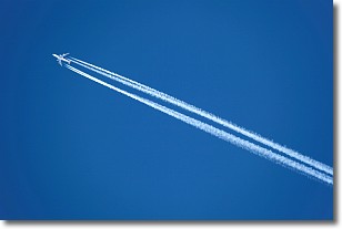
Weather Topic: What are Contrails?
Home - Education - Cloud Types - Contrails
 Next Topic: Cumulonimbus Clouds
A contrail is an artificial cloud, created by the passing of an
aircraft.
Contrails form because water vapor in the exhaust of aircraft engines is suspended
in the air under certain temperatures and humidity conditions. These contrails
are called exhaust contrails.
Another type of contrail can form due to a temporary reduction in air pressure
moving over the plane's surface, causing condensation.
These are called aerodynamic contrails.
When you can see your breath on a cold day, it is also because of condensation.
The reason contrails last longer than the condensation from your breath is
because the water in contrails freezes into ice particles.
Next Topic: Cumulonimbus Clouds
Current conditions powered by WeatherAPI.com


