Weather Alert in Alaska
Winter Weather Advisory issued August 26 at 10:01PM AKDT until August 28 at 10:00PM AKDT by NWS Fairbanks AK
AREAS AFFECTED: Central Beaufort Sea Coast
DESCRIPTION: * WHAT...Ice accumulations up to 0.05" possible. * WHERE...Central Arctic Plains, Central Beaufort Sea Coast, and Central Brooks Range. * WHEN...Until 10 PM AKDT Thursday. * IMPACTS...Plan on slippery road conditions. Any accumulating snow and freezing rain could create difficult travel conditions. * ADDITIONAL DETAILS...Though uncertainty remains substantial with the incoming storm system, confidence is increasing in light ice accumulations from one, potentially two periods of light freezing rain/freezing drizzle. The first would be Tuesday Night into Wednesday. During this time, precip types are more uncertain as temperatures are expected to hover within a couple degrees of the freezing mark. A second round of light freezing rain appears increasingly likely Thursday into Thursday night. The greatest ice accumulations will be for the Dalton Highway south of Prudhoe Bay, though hazardous driving conditions from icy road conditions will be possible all the way to the northern extent of the highway, especially by Thursday afternoon/evening.
INSTRUCTION: Slow down and use caution while traveling. The latest road conditions for the state you are calling from can be obtained by calling 5 1 1.
Want more detail? Get the Complete 7 Day and Night Detailed Forecast!
Current U.S. National Radar--Current
The Current National Weather Radar is shown below with a UTC Time (subtract 5 hours from UTC to get Eastern Time).

National Weather Forecast--Current
The Current National Weather Forecast and National Weather Map are shown below.

National Weather Forecast for Tomorrow
Tomorrow National Weather Forecast and Tomorrow National Weather Map are show below.

North America Water Vapor (Moisture)
This map shows recent moisture content over North America. Bright and colored areas show high moisture (ie, clouds); brown indicates very little moisture present; black indicates no moisture.

Weather Topic: What is Sleet?
Home - Education - Precipitation - Sleet
 Next Topic: Snow
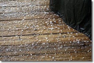
Sleet is a form of precipitation in which small ice pellets are the primary
components. These ice pellets are smaller and more translucent than hailstones,
and harder than graupel. Sleet is caused by specific atmospheric conditions and
therefore typically doesn't last for extended periods of time.
The condition which leads to sleet formation requires a warmer body of air to be
wedged in between two sub-freezing bodies of air. When snow falls through a warmer
layer of air it melts, and as it falls through the next sub-freezing body of air
it freezes again, forming ice pellets known as sleet. In some cases, water
droplets don't have time to freeze before reaching the surface and the result is
freezing rain.
Next Topic: Snow
Weather Topic: What are Stratocumulus Clouds?
Home - Education - Cloud Types - Stratocumulus Clouds
 Next Topic: Stratus Clouds
Stratocumulus clouds are similar to altocumulus clouds in their
fluffy appearance, but have a slightly darker shade due to their additional mass.
A good way to distinguish the two cloud types is to hold your hand out and measure
the size of an individual cloud; if it is the size of your thumb it is generally
an altocumulus cloud, if it is the size of your hand it is generally a
stratocumulus cloud.
It is uncommon for stratocumulus clouds to produce precipitation, but if they do
it is usually a light rain or snow.
Next Topic: Stratus Clouds
Current conditions powered by WeatherAPI.com


