Weather Alert in Minnesota
Flood Warning issued August 22 at 9:51AM CDT by NWS Twin Cities/Chanhassen MN
AREAS AFFECTED: Redwood, MN; Renville, MN
DESCRIPTION: ...The Flood Warning continues for the following rivers in Minnesota... Cottonwood River Above Springfield affecting Brown County. Minnesota River at New Ulm affecting Brown, Blue Earth and Nicollet Counties. Minnesota River at Granite Falls HWY 212 affecting Chippewa, Yellow Medicine and Renville Counties. Minnesota River at Morton affecting Renville and Redwood Counties. .Few changes to the forecast as we have had less water entering into the system over the past week and outside of today's rain there is little in the forecast. * WHAT...Moderate flooding is occurring and moderate flooding is forecast. * WHERE...Minnesota River at Morton. * WHEN...Until further notice. * IMPACTS...At 24.0 feet, Fleischer Rd flooded in North Redwood; storm sewers closed off and bypass pumping begins. * ADDITIONAL DETAILS... - At 900 AM CDT Friday, the stage was 24.5 feet. - Recent Activity...The maximum river stage in the 24 hours ending at 900 AM CDT Friday was 24.5 feet. - Forecast...The river is expected to rise to a crest of 24.5 feet this afternoon. - Flood stage is 21.0 feet. - Flood History...This crest compares to a previous crest of 24.4 feet on 03/31/2009.
INSTRUCTION: Turn around, don't drown when encountering flooded roads. Most flood deaths occur in vehicles. Motorists should not attempt to drive around barricades or drive cars through flooded areas. Caution is urged when walking near riverbanks.
Want more detail? Get the Complete 7 Day and Night Detailed Forecast!
Current U.S. National Radar--Current
The Current National Weather Radar is shown below with a UTC Time (subtract 5 hours from UTC to get Eastern Time).

National Weather Forecast--Current
The Current National Weather Forecast and National Weather Map are shown below.

National Weather Forecast for Tomorrow
Tomorrow National Weather Forecast and Tomorrow National Weather Map are show below.

North America Water Vapor (Moisture)
This map shows recent moisture content over North America. Bright and colored areas show high moisture (ie, clouds); brown indicates very little moisture present; black indicates no moisture.

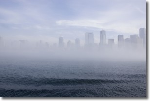
Weather Topic: What is Fog?
Home - Education - Cloud Types - Fog
 Next Topic: Fractus Clouds
Fog is technically a type of stratus cloud, which lies along the
ground and obscures visibility.
It is usually created when humidity in the air condenses into tiny water droplets.
Because of this, some places are more prone to foggy weather, such as regions
close to a body of water.
Fog is similar to mist; both are the appearance of water droplets suspended in
the air, but fog is the term applied to the condition when visibility is less than 1 km.
Next Topic: Fractus Clouds
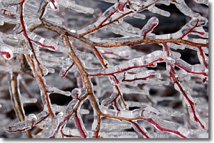
Weather Topic: What is Freezing Rain?
Home - Education - Precipitation - Freezing Rain
 Next Topic: Graupel
Freezing rain is a condition where precipitation which has fallen in the form of
water droplets reaches temperatures which are below freezing and freezes upon
coming into contact
with surface objects. The result of this precipitation is a glaze of ice which
can be damaging to plants and man-made structures. A severe onset of freezing
rain which results in a very thick glaze of ice is known as an ice storm.
Next Topic: Graupel
Current conditions powered by WeatherAPI.com


