Weather Alert in North Carolina
Tropical Cyclone Statement issued August 21 at 10:58PM EDT by NWS Newport/Morehead City NC
AREAS AFFECTED: Mainland Dare; East Carteret; Northern Outer Banks; Ocracoke Island; Hatteras Island
DESCRIPTION: HLSMHX This product covers Eastern North Carolina **HURRICANE ERIN MOVES FURTHER AWAY AS COASTAL IMPACTS LINGER** NEW INFORMATION --------------- * CHANGES TO WATCHES AND WARNINGS: - All watches and warnings have been canceled * CURRENT WATCHES AND WARNINGS: - None * STORM INFORMATION: - About 490 miles east-northeast of Buxton NC or about 570 miles east-northeast of Morehead City NC - 37.3N 67.0W - Storm Intensity 100 mph - Movement East-northeast or 60 degrees at 22 mph SITUATION OVERVIEW ------------------ Hurricane Erin continues pulling away from Eastern North Carolina and the Outer Banks tonight as a category 2 hurricane. Winds are steadily decreasing through the night and waves are slowly easing up through the weekend, but high tides through Friday night will continue bringing coastal impacts oceanside. Significant impacts from coastal flooding and ocean overwash are likely to continue for the Outer Banks portion of Dare County through Friday, with the highest impacts across Hatteras Island. Inundation of 2 to 3 feet with locally higher amounts can be expected around both the Friday morning high tide, and the Friday evening high tide. Portions of NC-12 may remain closed or restricted through the day Friday. Minor to moderate coastal flood inundation of 1 to 2 feet above ground level will continue oceanside across Ocracoke, the Crystal Coast, and Onslow beaches due to high astronomical tides and residual high water through the day Friday. Minor to locally moderate inundation of 1 to 2 ft can also be expected for soundside areas adjacent to the southern Pamlico Sound, and Core Sound through Friday. Strong rip currents are expected to continue along the Outer Banks Friday, likely continuing through the weekend north of Cape Hatteras. Continued erosion of beaches is also likely due to strong long period waves as high as 7 to 13 feet in the surf zone along the Outer Banks, highest north of Cape Hatteras. Hazardous marine conditions will continue for the coastal waters due to gusty winds tonight and dangerous seas through the weekend. Gusty winds will continue for inland sounds and rivers tonight. This will create dangerous conditions for mariners. POTENTIAL IMPACTS ----------------- * SURGE: See local coastal flooding products for more information PRECAUTIONARY/PREPAREDNESS ACTIONS ---------------------------------- * EVACUATIONS: Follow the advice of local officials. * OTHER PREPAREDNESS INFORMATION: Allow extra time for emergency vehicles to reach you as they navigate road hazards. Do not attempt to return to evacuated areas until local authorities give the all clear. Allow time for officials to inspect bridges and overpasses and to mark washed-out roads. Be alert for flooded roads which could be compromised or littered with debris. Avoid travel until water levels subside and roads have been cleared. Do not drive through places where flood waters cover the road. Turn around, don't drown! * ADDITIONAL SOURCES OF INFORMATION: - For information on appropriate preparations see ready.gov - For information on creating an emergency plan see getagameplan.org - For additional disaster preparedness information see redcross.org NEXT UPDATE ----------- As it pertains to this event...this will be the last local statement issued by the National Weather Service in Newport/Morehead City NC regarding the effects of tropical cyclone hazards upon the area.
INSTRUCTION: N/A
Want more detail? Get the Complete 7 Day and Night Detailed Forecast!
Current U.S. National Radar--Current
The Current National Weather Radar is shown below with a UTC Time (subtract 5 hours from UTC to get Eastern Time).

National Weather Forecast--Current
The Current National Weather Forecast and National Weather Map are shown below.

National Weather Forecast for Tomorrow
Tomorrow National Weather Forecast and Tomorrow National Weather Map are show below.

North America Water Vapor (Moisture)
This map shows recent moisture content over North America. Bright and colored areas show high moisture (ie, clouds); brown indicates very little moisture present; black indicates no moisture.

Weather Topic: What is Freezing Rain?
Home - Education - Precipitation - Freezing Rain
 Next Topic: Graupel
Freezing rain is a condition where precipitation which has fallen in the form of
water droplets reaches temperatures which are below freezing and freezes upon
coming into contact
with surface objects. The result of this precipitation is a glaze of ice which
can be damaging to plants and man-made structures. A severe onset of freezing
rain which results in a very thick glaze of ice is known as an ice storm.
Next Topic: Graupel
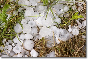
Weather Topic: What is Hail?
Home - Education - Precipitation - Hail
 Next Topic: Hole Punch Clouds
Hail is a form of precipitation which is recognized by large solid balls or
clumps of ice. Hail is created by thunderstorm clouds with strong updrafts of wind.
As the hailstones remain in the updraft, ice is deposited onto them until their
weight becomes heavy enough for them to fall to the earth's surface.
Hail storms can cause significant damage to crops, aircrafts, and man-made structures,
despite the fact that the duration is usually less than ten minutes.
Next Topic: Hole Punch Clouds
Current conditions powered by WeatherAPI.com


