Weather Alert in Oregon
Winter Weather Advisory issued March 4 at 9:33AM PST until March 5 at 4:00AM PST by NWS Portland OR
AREAS AFFECTED: Cascades of Marion and Linn Counties; Cascades of Lane County
DESCRIPTION: * WHAT...Snow above 4000 ft. Additional snow accumulations up to 9 to 11 inches at Santiam and Willamette Passes. Winds gusting as high as 35 mph. * WHERE...Cascades of Lane County and Cascades of Marion and Linn Counties. * WHEN...Until 4 AM PST Thursday. * IMPACTS...Roads, and especially bridges and overpasses, will likely become slick and hazardous. Periods of moderate to heavy snowfall combined with low visibilities may create difficult driving conditions. * ADDITIONAL DETAILS...Fairly uniform snow late Wednesday morning will transition to showers in the afternoon. Heaviest snowfall rates are expected between now and 6 PM Wednesday.
INSTRUCTION: Be prepared for slippery roads. Slow down and use caution while driving. If you are going outside, watch your first few steps taken on stairs, sidewalks, and driveways. These surfaces could be slippery, increasing your risk of a fall and injury. Have a winter emergency driving kit readily available. Common items to include: flashlight, batteries, blankets, a shovel, water, non-perishable food items, tire chains, etc. For the latest road conditions and chain restrictions in Oregon, call 5 1 1, or visit: www.tripcheck.com. For the latest road conditions and chain restrictions in Washington, visit: wsdot.com/travel/real-time/map
Want more detail? Get the Complete 7 Day and Night Detailed Forecast!
Current U.S. National Radar--Current
The Current National Weather Radar is shown below with a UTC Time (subtract 5 hours from UTC to get Eastern Time).

National Weather Forecast--Current
The Current National Weather Forecast and National Weather Map are shown below.

National Weather Forecast for Tomorrow
Tomorrow National Weather Forecast and Tomorrow National Weather Map are show below.

North America Water Vapor (Moisture)
This map shows recent moisture content over North America. Bright and colored areas show high moisture (ie, clouds); brown indicates very little moisture present; black indicates no moisture.

Weather Topic: What is Hail?
Home - Education - Precipitation - Hail
 Next Topic: Hole Punch Clouds
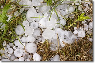
Hail is a form of precipitation which is recognized by large solid balls or
clumps of ice. Hail is created by thunderstorm clouds with strong updrafts of wind.
As the hailstones remain in the updraft, ice is deposited onto them until their
weight becomes heavy enough for them to fall to the earth's surface.
Hail storms can cause significant damage to crops, aircrafts, and man-made structures,
despite the fact that the duration is usually less than ten minutes.
Next Topic: Hole Punch Clouds
Weather Topic: What are Mammatus Clouds?
Home - Education - Cloud Types - Mammatus Clouds
 Next Topic: Nimbostratus Clouds
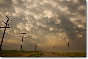
A mammatus cloud is a cloud with a unique feature which resembles
a web of pouches hanging along the base of the cloud.
In the United States, mammatus clouds tend to form in the warmer months, commonly
in the Midwest and eastern regions.
While they usually form at the bottom of a cumulonimbis cloud, they can also form
under altostratus, altocumulus, stratocumulus, and cirrus clouds. Mammatus clouds
warn that severe weather is close.
Next Topic: Nimbostratus Clouds
Current conditions powered by WeatherAPI.com


