Weather Alert in Illinois
Severe Thunderstorm Watch issued March 4 at 2:32PM CST until March 4 at 9:00PM CST by NWS Paducah KY
AREAS AFFECTED: Alexander, IL; Edwards, IL; Franklin, IL; Gallatin, IL; Hamilton, IL; Hardin, IL; Jackson, IL; Jefferson, IL; Johnson, IL; Massac, IL; Perry, IL; Pope, IL; Pulaski, IL; Saline, IL; Union, IL; Wabash, IL; Wayne, IL; White, IL; Williamson, IL; Gibson, IN; Pike, IN; Posey, IN; Spencer, IN; Vanderburgh, IN; Warrick, IN; Ballard, KY; Carlisle, KY; Crittenden, KY; Daviess, KY; Fulton, KY; Henderson, KY; Hickman, KY; Livingston, KY; McCracken, KY; Union, KY; Webster, KY; Bollinger, MO; Butler, MO; Cape Girardeau, MO; Carter, MO; Mississippi, MO; New Madrid, MO; Perry, MO; Ripley, MO; Scott, MO; Stoddard, MO; Wayne, MO
DESCRIPTION: THE NATIONAL WEATHER SERVICE HAS ISSUED SEVERE THUNDERSTORM WATCH 11 IN EFFECT UNTIL 9 PM CST /10 PM EST/ THIS EVENING FOR THE FOLLOWING AREAS IN ILLINOIS THIS WATCH INCLUDES 19 COUNTIES IN SOUTHEAST ILLINOIS EDWARDS IN SOUTHERN ILLINOIS ALEXANDER FRANKLIN GALLATIN HAMILTON HARDIN JACKSON JEFFERSON JOHNSON MASSAC PERRY POPE PULASKI SALINE UNION WABASH WAYNE WHITE WILLIAMSON IN INDIANA THIS WATCH INCLUDES 6 COUNTIES IN SOUTHWEST INDIANA POSEY IN SOUTHWEST INDIANA GIBSON PIKE SPENCER VANDERBURGH WARRICK IN KENTUCKY THIS WATCH INCLUDES 11 COUNTIES IN WESTERN KENTUCKY BALLARD CARLISLE CRITTENDEN DAVIESS FULTON HENDERSON HICKMAN LIVINGSTON MCCRACKEN UNION WEBSTER IN MISSOURI THIS WATCH INCLUDES 11 COUNTIES IN SOUTHEAST MISSOURI BOLLINGER BUTLER CAPE GIRARDEAU CARTER MISSISSIPPI NEW MADRID PERRY RIPLEY SCOTT STODDARD WAYNE THIS INCLUDES THE CITIES OF ALBION, BARDWELL, BLOOMFIELD, BOONVILLE, CAIRO, CAPE GIRARDEAU, CARBONDALE, CARMI, CHARLESTON, CLINTON, DIXON, DONIPHAN, ELIZABETHTOWN, EVANSVILLE, FAIRFIELD, FORT BRANCH, GOLCONDA, GRAYVILLE, HARRISBURG, HENDERSON, HERRIN, HICKMAN, JACKSON, JONESBORO, MARBLE HILL, MARION, MCLEANSBORO, METROPOLIS, MORGANFIELD, MOUND CITY, MOUNT CARMEL, MOUNT VERNON, MURPHYSBORO, NEW MADRID, OWENSBORO, PADUCAH, PERRYVILLE, PETERSBURG, PIEDMONT, PINCKNEYVILLE, POPLAR BLUFF, POSEYVILLE, ROCKPORT, SHAWNEETOWN, SIKESTON, SMITHLAND, VAN BUREN, VIENNA, WEST FRANKFORT, WEST SALEM, AND WICKLIFFE.
INSTRUCTION: N/A
Want more detail? Get the Complete 7 Day and Night Detailed Forecast!
Current U.S. National Radar--Current
The Current National Weather Radar is shown below with a UTC Time (subtract 5 hours from UTC to get Eastern Time).

National Weather Forecast--Current
The Current National Weather Forecast and National Weather Map are shown below.

National Weather Forecast for Tomorrow
Tomorrow National Weather Forecast and Tomorrow National Weather Map are show below.

North America Water Vapor (Moisture)
This map shows recent moisture content over North America. Bright and colored areas show high moisture (ie, clouds); brown indicates very little moisture present; black indicates no moisture.

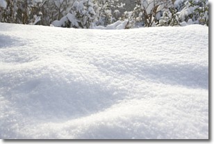
Weather Topic: What is Snow?
Home - Education - Precipitation - Snow
 Next Topic: Stratocumulus Clouds
Snow is precipitation taking the form of ice crystals. Each ice crystal, or snowflake,
has unique characteristics, but all of them grow in a hexagonal structure.
Snowfall can last for sustained periods of time and result in significant buildup
of snow on the ground.
On the earth's surface, snow starts out light and powdery, but as it begins to melt
it tends to become more granular, producing small bits of ice which have the consistency of
sand. After several cycles of melting and freezing, snow can become very dense
and ice-like, commonly known as snow pack.
Next Topic: Stratocumulus Clouds
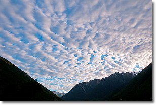
Weather Topic: What are Stratus Clouds?
Home - Education - Cloud Types - Stratus Clouds
 Next Topic: Wall Clouds
Stratus clouds are similar to altostratus clouds, but form at a
lower altitude and are identified by their fog-like appearance, lacking the
distinguishing features of most clouds.
Stratus clouds are wider than most clouds, and their base has a smooth, uniform
look which is lighter in color than a nimbostratus cloud.
The presence of a stratus cloud indicates the possibility of minor precipitation,
such as drizzle, but heavier precipitation does not typically arrive in the form
of a stratus cloud.
Next Topic: Wall Clouds
Current conditions powered by WeatherAPI.com


