Weather Alert in Connecticut
Severe Thunderstorm Warning issued September 6 at 3:15PM EDT until September 6 at 4:00PM EDT by NWS Upton NY
AREAS AFFECTED: Fairfield, CT; Middlesex, CT; New Haven, CT
DESCRIPTION: SVROKX The National Weather Service in Upton NY has issued a * Severe Thunderstorm Warning for... Fairfield County in southern Connecticut... Northern Middlesex County in southern Connecticut... New Haven County in southern Connecticut... * Until 400 PM EDT. * At 315 PM EDT, severe thunderstorms were located along a line extending from Brookfield to Redding to near Georgetown to near New Canaan to Greenwich, moving east at 40 mph. HAZARD...60 mph wind gusts. SOURCE...Radar indicated. IMPACT...Expect damage to trees and power lines. * Severe thunderstorms will be near... Stamford and Norwalk around 320 PM EDT. Fairfield around 325 PM EDT. Bridgeport and Shelton around 330 PM EDT. Waterbury and Naugatuck around 335 PM EDT. Wolcott and Stratford around 340 PM EDT. Milford and Hamden around 345 PM EDT. New Haven around 350 PM EDT.
INSTRUCTION: For your protection move to an interior room on the lowest floor of a building.
Want more detail? Get the Complete 7 Day and Night Detailed Forecast!
Current U.S. National Radar--Current
The Current National Weather Radar is shown below with a UTC Time (subtract 5 hours from UTC to get Eastern Time).

National Weather Forecast--Current
The Current National Weather Forecast and National Weather Map are shown below.

National Weather Forecast for Tomorrow
Tomorrow National Weather Forecast and Tomorrow National Weather Map are show below.

North America Water Vapor (Moisture)
This map shows recent moisture content over North America. Bright and colored areas show high moisture (ie, clouds); brown indicates very little moisture present; black indicates no moisture.

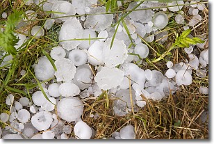
Weather Topic: What is Hail?
Home - Education - Precipitation - Hail
 Next Topic: Hole Punch Clouds
Hail is a form of precipitation which is recognized by large solid balls or
clumps of ice. Hail is created by thunderstorm clouds with strong updrafts of wind.
As the hailstones remain in the updraft, ice is deposited onto them until their
weight becomes heavy enough for them to fall to the earth's surface.
Hail storms can cause significant damage to crops, aircrafts, and man-made structures,
despite the fact that the duration is usually less than ten minutes.
Next Topic: Hole Punch Clouds
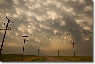
Weather Topic: What are Mammatus Clouds?
Home - Education - Cloud Types - Mammatus Clouds
 Next Topic: Nimbostratus Clouds
A mammatus cloud is a cloud with a unique feature which resembles
a web of pouches hanging along the base of the cloud.
In the United States, mammatus clouds tend to form in the warmer months, commonly
in the Midwest and eastern regions.
While they usually form at the bottom of a cumulonimbis cloud, they can also form
under altostratus, altocumulus, stratocumulus, and cirrus clouds. Mammatus clouds
warn that severe weather is close.
Next Topic: Nimbostratus Clouds
Current conditions powered by WeatherAPI.com


