Weather Alert in North Carolina
Tropical Storm Warning issued July 5 at 11:00AM EDT by NWS Wilmington NC
AREAS AFFECTED: Coastal Pender
DESCRIPTION: A Tropical Storm Warning means tropical storm-force winds are expected somewhere within this area within the next 36 hours * LOCATIONS AFFECTED - Surf City - Hampstead * WIND - LATEST LOCAL FORECAST: Below tropical storm force wind - Peak Wind Forecast: 20-30 mph with gusts to 35 mph - THREAT TO LIFE AND PROPERTY THAT INCLUDES TYPICAL FORECAST UNCERTAINTY IN TRACK, SIZE AND INTENSITY: Potential for wind 39 to 57 mph - The wind threat has increased from the previous assessment. - PLAN: Plan for hazardous wind of equivalent tropical storm force. - PREPARE: Efforts to protect property should now be underway. Prepare for limited wind damage. - ACT: Act now to complete preparations before the wind becomes hazardous. - POTENTIAL IMPACTS: Limited - Damage to porches, awnings, carports, sheds, and unanchored mobile homes is possible. Unsecured lightweight objects may be blown about. - Some large limbs may break from trees. A few shallow rooted or weak trees may snap or be knocked down. Some fences and roadway signs will be damaged. - A few roads may become impassable due to debris, particularly within urban or heavily wooded places. Hazardous driving conditions are possible, especially for high profile vehicles on bridges and other elevated roadways. - Scattered power and communications outages are possible. * STORM SURGE - LATEST LOCAL FORECAST: Localized storm surge possible - Peak Storm Surge Inundation: The potential for 1-3 feet above ground somewhere within surge prone areas - Window of concern: through this evening - THREAT TO LIFE AND PROPERTY THAT INCLUDES TYPICAL FORECAST UNCERTAINTY IN TRACK, SIZE AND INTENSITY: Potential for storm surge flooding greater than 1 foot above ground - The storm surge threat has increased from the previous assessment. - PLAN: Shelter against storm surge flooding greater than 1 foot above ground. - PREPARE: All flood preparations should be complete. Expect flooding of low-lying roads and property. - ACT: Stay away from storm surge prone areas. Continue to follow the instructions of local officials. - POTENTIAL IMPACTS: Unfolding - Potential impacts from the main surge event are unfolding. * FLOODING RAIN - LATEST LOCAL FORECAST: - Peak Rainfall Amounts: Additional 1-3 inches, with locally higher amounts - THREAT TO LIFE AND PROPERTY THAT INCLUDES TYPICAL FORECAST UNCERTAINTY IN TRACK, SIZE AND INTENSITY: Potential for localized flooding rain - The flooding rain threat has remained nearly steady from the previous assessment. - PLAN: Emergency plans should include the potential for localized flooding from heavy rain. - PREPARE: Consider protective actions if you are in an area vulnerable to flooding. - ACT: Heed any flood watches and warnings. - POTENTIAL IMPACTS: Limited - Localized flooding from rainfall may occur, especially in low-lying and poor drainage areas. Some rivers and creeks may rise as a result of the rain. Small streams, creeks, and ditches may overflow in some locations. - Several storm drains and retention ponds may become full and begin to overflow. Some brief road closures are possible. * TORNADO - LATEST LOCAL FORECAST: - Situation is somewhat favorable for tornadoes - THREAT TO LIFE AND PROPERTY THAT INCLUDES TYPICAL FORECAST UNCERTAINTY IN TRACK, SIZE AND INTENSITY: Potential for a few tornadoes - The tornado threat has increased from the previous assessment. - PLAN: Emergency plans should include the potential for a few tornadoes. - PREPARE: If your shelter is particularly vulnerable to tornadoes, prepare to relocate to safe shelter before hazardous weather arrives. - ACT: If a tornado warning is issued, be ready to shelter quickly. - POTENTIAL IMPACTS: Limited - The occurrence of isolated tornadoes can hinder preparedness actions during tropical events. - A few places may experience tornado damage, along with power and communications disruptions. - Tornadoes can cause damage to trees, vehicles, boats, and buildings. Unsecured mobile homes and poorly constructed structures are particularly vulnerable. * FOR MORE INFORMATION: - http://www.weather.gov/ilm/tropical - http://ready.gov/hurricanes - http://readyNC.gov
INSTRUCTION: N/A
Want more detail? Get the Complete 7 Day and Night Detailed Forecast!
Current U.S. National Radar--Current
The Current National Weather Radar is shown below with a UTC Time (subtract 5 hours from UTC to get Eastern Time).

National Weather Forecast--Current
The Current National Weather Forecast and National Weather Map are shown below.

National Weather Forecast for Tomorrow
Tomorrow National Weather Forecast and Tomorrow National Weather Map are show below.

North America Water Vapor (Moisture)
This map shows recent moisture content over North America. Bright and colored areas show high moisture (ie, clouds); brown indicates very little moisture present; black indicates no moisture.

Weather Topic: What is Hail?
Home - Education - Precipitation - Hail
 Next Topic: Hole Punch Clouds
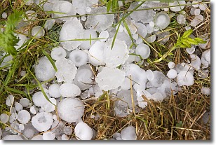
Hail is a form of precipitation which is recognized by large solid balls or
clumps of ice. Hail is created by thunderstorm clouds with strong updrafts of wind.
As the hailstones remain in the updraft, ice is deposited onto them until their
weight becomes heavy enough for them to fall to the earth's surface.
Hail storms can cause significant damage to crops, aircrafts, and man-made structures,
despite the fact that the duration is usually less than ten minutes.
Next Topic: Hole Punch Clouds
Weather Topic: What are Mammatus Clouds?
Home - Education - Cloud Types - Mammatus Clouds
 Next Topic: Nimbostratus Clouds
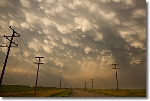
A mammatus cloud is a cloud with a unique feature which resembles
a web of pouches hanging along the base of the cloud.
In the United States, mammatus clouds tend to form in the warmer months, commonly
in the Midwest and eastern regions.
While they usually form at the bottom of a cumulonimbis cloud, they can also form
under altostratus, altocumulus, stratocumulus, and cirrus clouds. Mammatus clouds
warn that severe weather is close.
Next Topic: Nimbostratus Clouds
Current conditions powered by WeatherAPI.com


