Weather Alert in Florida
Cold Weather Advisory issued February 23 at 12:22AM EST until February 24 at 9:00AM EST by NWS Jacksonville FL
AREAS AFFECTED: Suwannee; Union; Bradford; Gilchrist; Inland Flagler; Coastal Nassau; Coastal Duval; Eastern Clay; Eastern Alachua; Eastern Putnam; Coastal Flagler; Eastern Marion; Trout River; Western Clay; Northeast Coastal St. Johns; Western Alachua; Western Putnam; Central Marion; South Central Duval; Southeast Coastal St. Johns; Western Marion; Southeastern Columbia; Western Duval; Northern Inland St. Johns; Southwestern Columbia; Southern Inland St. Johns; Western St. Johns
DESCRIPTION: * WHAT...For the first Cold Weather Advisory, very cold wind chills as low as 23 expected. For the Freeze Warning, sub-freezing temperatures as low as 26 expected. For the second Cold Weather Advisory, very cold wind chills as low as 20 expected. * WHERE...Portions of northeast and northern Florida. * WHEN...For the first Cold Weather Advisory, from 4 AM to 9 AM EST this morning. For the Freeze Warning, from midnight tonight to 9 AM EST Tuesday. For the second Cold Weather Advisory, from 2 AM to 9 AM EST Tuesday. * IMPACTS...The cold wind chills as low as 25 degrees could result in hypothermia or frostbite if precautions are not taken. Wind chill values can lead to hypothermia with prolonged exposure. Appropriate action should be taken to ensure tender vegetation and outdoor pets have adequate protection from the cold temperatures. Young children, the elderly and the homeless are especially vulnerable to the cold. Take measures to protect them.
INSTRUCTION: Use caution while traveling outside. Wear appropriate clothing, a hat, and gloves. Keep pets indoors as much as possible. If you do not have heat in your home or lack shelter, you can call 211 for assistance locating appropriate shelter from the cold. Take steps now to protect tender plants from the cold.
Want more detail? Get the Complete 7 Day and Night Detailed Forecast!
Current U.S. National Radar--Current
The Current National Weather Radar is shown below with a UTC Time (subtract 5 hours from UTC to get Eastern Time).

National Weather Forecast--Current
The Current National Weather Forecast and National Weather Map are shown below.

National Weather Forecast for Tomorrow
Tomorrow National Weather Forecast and Tomorrow National Weather Map are show below.

North America Water Vapor (Moisture)
This map shows recent moisture content over North America. Bright and colored areas show high moisture (ie, clouds); brown indicates very little moisture present; black indicates no moisture.

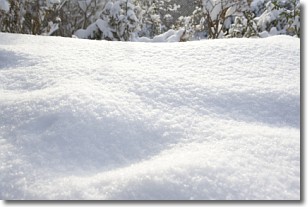
Weather Topic: What is Snow?
Home - Education - Precipitation - Snow
 Next Topic: Stratocumulus Clouds
Snow is precipitation taking the form of ice crystals. Each ice crystal, or snowflake,
has unique characteristics, but all of them grow in a hexagonal structure.
Snowfall can last for sustained periods of time and result in significant buildup
of snow on the ground.
On the earth's surface, snow starts out light and powdery, but as it begins to melt
it tends to become more granular, producing small bits of ice which have the consistency of
sand. After several cycles of melting and freezing, snow can become very dense
and ice-like, commonly known as snow pack.
Next Topic: Stratocumulus Clouds
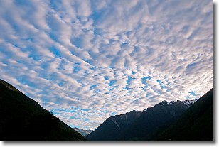
Weather Topic: What are Stratus Clouds?
Home - Education - Cloud Types - Stratus Clouds
 Next Topic: Wall Clouds
Stratus clouds are similar to altostratus clouds, but form at a
lower altitude and are identified by their fog-like appearance, lacking the
distinguishing features of most clouds.
Stratus clouds are wider than most clouds, and their base has a smooth, uniform
look which is lighter in color than a nimbostratus cloud.
The presence of a stratus cloud indicates the possibility of minor precipitation,
such as drizzle, but heavier precipitation does not typically arrive in the form
of a stratus cloud.
Next Topic: Wall Clouds
Current conditions powered by WeatherAPI.com


