Weather Alert in Florida
Freeze Warning issued February 23 at 12:22AM EST until February 24 at 9:00AM EST by NWS Jacksonville FL
AREAS AFFECTED: Baker; Inland Nassau; Eastern Hamilton; Western Hamilton; Northern Columbia
DESCRIPTION: * WHAT...For the first Freeze Warning, sub-freezing temperatures as low as 30. For the first Cold Weather Advisory, very cold wind chills as low as 20 expected. For the second Freeze Warning, sub-freezing temperatures as low as 26 expected, a hard freeze is possible for some locations. For the second Cold Weather Advisory, very cold wind chills as low as 20 expected. * WHERE...Baker, Inland Nassau, Eastern Hamilton, Northern Columbia, and Western Hamilton Counties. * WHEN...For the first Freeze Warning, until 9 AM EST this morning. For the first Cold Weather Advisory, from 4 AM to 9 AM EST this morning. For the second Freeze Warning, from midnight tonight to 9 AM EST Tuesday. For the second Cold Weather Advisory, from 2 AM to 9 AM EST Tuesday. * IMPACTS...The cold wind chills as low as 20 degrees could result in hypothermia or frostbite if precautions are not taken. Wind chill values can lead to hypothermia with prolonged exposure. Appropriate action should be taken to ensure tender vegetation and outdoor pets have adequate protection from the cold temperatures. Young children, the elderly and the homeless are especially vulnerable to the cold. Take measures to protect them.
INSTRUCTION: Use caution while traveling outside. Wear appropriate clothing, a hat, and gloves. Keep pets indoors as much as possible. If you do not have heat in your home or lack shelter, you can call 211 for assistance locating appropriate shelter from the cold. Take steps now to protect tender plants from the cold.
Want more detail? Get the Complete 7 Day and Night Detailed Forecast!
Current U.S. National Radar--Current
The Current National Weather Radar is shown below with a UTC Time (subtract 5 hours from UTC to get Eastern Time).

National Weather Forecast--Current
The Current National Weather Forecast and National Weather Map are shown below.

National Weather Forecast for Tomorrow
Tomorrow National Weather Forecast and Tomorrow National Weather Map are show below.

North America Water Vapor (Moisture)
This map shows recent moisture content over North America. Bright and colored areas show high moisture (ie, clouds); brown indicates very little moisture present; black indicates no moisture.

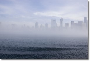
Weather Topic: What is Fog?
Home - Education - Cloud Types - Fog
 Next Topic: Fractus Clouds
Fog is technically a type of stratus cloud, which lies along the
ground and obscures visibility.
It is usually created when humidity in the air condenses into tiny water droplets.
Because of this, some places are more prone to foggy weather, such as regions
close to a body of water.
Fog is similar to mist; both are the appearance of water droplets suspended in
the air, but fog is the term applied to the condition when visibility is less than 1 km.
Next Topic: Fractus Clouds
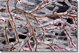
Weather Topic: What is Freezing Rain?
Home - Education - Precipitation - Freezing Rain
 Next Topic: Graupel
Freezing rain is a condition where precipitation which has fallen in the form of
water droplets reaches temperatures which are below freezing and freezes upon
coming into contact
with surface objects. The result of this precipitation is a glaze of ice which
can be damaging to plants and man-made structures. A severe onset of freezing
rain which results in a very thick glaze of ice is known as an ice storm.
Next Topic: Graupel
Current conditions powered by WeatherAPI.com


