Weather Alert in New Mexico
Fire Weather Watch issued March 4 at 10:19PM MST until March 6 at 7:00PM MST by NWS Albuquerque NM
AREAS AFFECTED: Northeast Plains; Northeast Highlands; Central Highlands; East Central Plains
DESCRIPTION: ...RED FLAG WARNING IN EFFECT FROM 11 AM TO 7 PM MST THURSDAY... ...FIRE WEATHER WATCH IN EFFECT FROM FRIDAY MORNING THROUGH FRIDAY EVENING...... .Critical fire weather conditions are expected Thursday afternoon across eastern NM. Strong southwest winds, above normal temperatures, single digit humidity, and dry fuels will increase the threat of rapid fire spread. Between 3 and 7 hours of single digit humidity values are expected, with winds gusts between 35 and 45 mph. Winds will slowly decrease Thursday evening, but remain elevated over parts of the central and northeast highlands. Strong winds return to the eastern plains on Friday afternoon, once again increasing the threat of rapid fire spread. * AREA AND TIMING...This includes the Northeast Plains (Zone 104), Northeast Highlands (Zone 123), East-Central Plains (Zone 126), and Central Highlands (Zone 125) from 11 AM MST to 7 PM MST Thursday for the Red Flag Warning and 11 AM MST to 7 PM MST Friday for the Fire Weather Watch. * 20 FOOT WINDS...Southwest 25 to 35 mph with gusts up to 45 mph. * RELATIVE HUMIDITY...Minimum values between 6 and 10 percent. * IMPACTS...Any fires that develop will likely spread rapidly. Outdoor burning is not recommended.
INSTRUCTION: Please advise the appropriate officials or fire crews in the field of this Red Flag Warning.
Want more detail? Get the Complete 7 Day and Night Detailed Forecast!
Current U.S. National Radar--Current
The Current National Weather Radar is shown below with a UTC Time (subtract 5 hours from UTC to get Eastern Time).

National Weather Forecast--Current
The Current National Weather Forecast and National Weather Map are shown below.

National Weather Forecast for Tomorrow
Tomorrow National Weather Forecast and Tomorrow National Weather Map are show below.

North America Water Vapor (Moisture)
This map shows recent moisture content over North America. Bright and colored areas show high moisture (ie, clouds); brown indicates very little moisture present; black indicates no moisture.

Weather Topic: What is Freezing Rain?
Home - Education - Precipitation - Freezing Rain
 Next Topic: Graupel
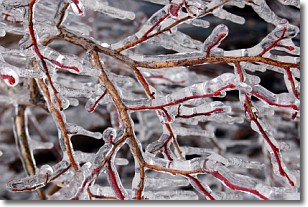
Freezing rain is a condition where precipitation which has fallen in the form of
water droplets reaches temperatures which are below freezing and freezes upon
coming into contact
with surface objects. The result of this precipitation is a glaze of ice which
can be damaging to plants and man-made structures. A severe onset of freezing
rain which results in a very thick glaze of ice is known as an ice storm.
Next Topic: Graupel
Weather Topic: What is Hail?
Home - Education - Precipitation - Hail
 Next Topic: Hole Punch Clouds
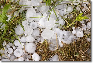
Hail is a form of precipitation which is recognized by large solid balls or
clumps of ice. Hail is created by thunderstorm clouds with strong updrafts of wind.
As the hailstones remain in the updraft, ice is deposited onto them until their
weight becomes heavy enough for them to fall to the earth's surface.
Hail storms can cause significant damage to crops, aircrafts, and man-made structures,
despite the fact that the duration is usually less than ten minutes.
Next Topic: Hole Punch Clouds
Current conditions powered by WeatherAPI.com


