Weather Alert in Texas
Flood Warning issued July 5 at 5:48AM CDT until July 6 at 1:29PM CDT by NWS Austin/San Antonio TX
AREAS AFFECTED: Williamson, TX
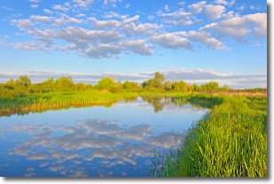
DESCRIPTION: ...Forecast flooding changed from Moderate to Major severity and increased in duration for the following rivers in Texas... South Fork San Gabriel River At Georgetown affecting Williamson County. * WHAT...Major flooding is forecast. * WHERE...South Fork San Gabriel River at Georgetown. * WHEN...Until early tomorrow afternoon. * IMPACTS...At 26.0 feet, Major lowland flooding closes many streets and roads. Much of the city park downstream floods. Lowest homes above Georgetown to Granger Lake are threatened. * ADDITIONAL DETAILS... - At 7:15 PM CDT Friday the stage was 4.6 feet. - Bankfull stage is 5.0 feet. - Forecast...The river is expected to rise to a crest of 29.7 feet this afternoon. It will then fall below flood stage just after midnight tonight. - Flood stage is 9.0 feet. - Flood History...This crest compares to a previous crest of 31.7 feet on 06/27/2007. - http://www.weather.gov/safety/flood
INSTRUCTION: Turn around, don't drown when encountering flooded roads. Most flood deaths occur in vehicles. Caution is urged when walking near riverbanks. Even 6 inches of fast-moving flood water can knock you off your feet and a depth of 2 feet will float your car. Never try to walk, swim, or drive through such swift water. If you come upon flood waters, stop, turn around and go another way. Please report observed flooding to local emergency services or law enforcement and request they pass this information to the National Weather Service when you can do so safely. Additional information is available at www.weather.gov. The next statement will be issued late tonight by midnight CDT.
Want more detail? Get the Complete 7 Day and Night Detailed Forecast!
Current U.S. National Radar--Current
The Current National Weather Radar is shown below with a UTC Time (subtract 5 hours from UTC to get Eastern Time).

National Weather Forecast--Current
The Current National Weather Forecast and National Weather Map are shown below.

National Weather Forecast for Tomorrow
Tomorrow National Weather Forecast and Tomorrow National Weather Map are show below.

North America Water Vapor (Moisture)
This map shows recent moisture content over North America. Bright and colored areas show high moisture (ie, clouds); brown indicates very little moisture present; black indicates no moisture.

Weather Topic: What are Stratocumulus Clouds?
Home - Education - Cloud Types - Stratocumulus Clouds
 Next Topic: Stratus Clouds
Stratocumulus clouds are similar to altocumulus clouds in their
fluffy appearance, but have a slightly darker shade due to their additional mass.
A good way to distinguish the two cloud types is to hold your hand out and measure
the size of an individual cloud; if it is the size of your thumb it is generally
an altocumulus cloud, if it is the size of your hand it is generally a
stratocumulus cloud.
It is uncommon for stratocumulus clouds to produce precipitation, but if they do
it is usually a light rain or snow.
Next Topic: Stratus Clouds
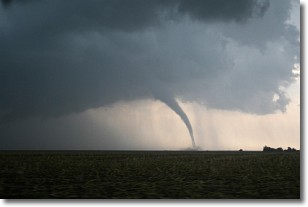
Weather Topic: What are Wall Clouds?
Home - Education - Cloud Types - Wall Clouds
 Next Topic: Altocumulus Clouds
A wall cloud forms underneath the base of a cumulonimbus cloud,
and can be a hotbed for deadly tornadoes.
Wall clouds are formed by air flowing into the cumulonimbus clouds, which can
result in the wall cloud descending from the base of the cumulonimbus cloud, or
rising fractus clouds which join to the base of the storm cloud as the wall cloud
takes shape.
Wall clouds can be very large, and in the Northern Hemisphere they generally
form at the southern edge of cumulonimbus clouds.
Next Topic: Altocumulus Clouds
Current conditions powered by WeatherAPI.com


