Weather Alert in Texas
Flood Warning issued July 5 at 1:27AM CDT until July 5 at 9:22PM CDT by NWS Austin/San Antonio TX
AREAS AFFECTED: Comal, TX
DESCRIPTION: ...The Flood Warning continues for the following rivers in Texas... Guadalupe River Near Spring Branch affecting Comal County. * WHAT...Moderate flooding is forecast. * WHERE...Guadalupe River near Spring Branch. * WHEN...Until late Saturday evening. * IMPACTS...At 36.0 feet, Moderate lowland flooding reaches secondary roads and low bridges in the flood plain. Recreationists should evacuate the river banks because of dangerous turbulent flow. Low sections of Guadalupe River State Park have tables, trash cans, and equiment damaged. Lowest homes in Kendall County to Canyon Lake flood. At 39.0 feet, Major flooding reaches secondary roads and low bridges near the river making them extremely dangerous to motorists. The lowest residences flood from Kendall County to Canyon Lake. Picnic and camping facilities in Guadalupe River State Park upstream are severely flooded. Roads, marinas, and many parks and facilities at Canyon Lake flood. * ADDITIONAL DETAILS... - At 1:00 AM CDT Saturday the stage was 23.5 feet. - Bankfull stage is 25.0 feet. - Forecast...The river is expected to rise above flood stage early this morning to a crest of 37.9 feet early this morning. It will then fall below flood stage late this morning. - Flood stage is 30.0 feet. - Flood History...This crest compares to a previous crest of 38.0 feet on 12/21/1991. - http://www.weather.gov/safety/flood
INSTRUCTION: Caution is urged when walking near riverbanks. To escape rising water, take the shortest path to higher ground. Turn around, don't drown when encountering flooded roads. Most flood deaths occur in vehicles. Be especially cautious at night when it is harder to recognize the dangers of flooding. Even 6 inches of fast-moving flood water can knock you off your feet and a depth of 2 feet will float your car. Never try to walk, swim, or drive through such swift water. If you come upon flood waters, stop, turn around and go another way. Additional information is available at www.weather.gov. The next statement will be issued this evening by 730 PM CDT.
Want more detail? Get the Complete 7 Day and Night Detailed Forecast!
Current U.S. National Radar--Current
The Current National Weather Radar is shown below with a UTC Time (subtract 5 hours from UTC to get Eastern Time).

National Weather Forecast--Current
The Current National Weather Forecast and National Weather Map are shown below.

National Weather Forecast for Tomorrow
Tomorrow National Weather Forecast and Tomorrow National Weather Map are show below.

North America Water Vapor (Moisture)
This map shows recent moisture content over North America. Bright and colored areas show high moisture (ie, clouds); brown indicates very little moisture present; black indicates no moisture.

Weather Topic: What is Hail?
Home - Education - Precipitation - Hail
 Next Topic: Hole Punch Clouds
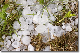
Hail is a form of precipitation which is recognized by large solid balls or
clumps of ice. Hail is created by thunderstorm clouds with strong updrafts of wind.
As the hailstones remain in the updraft, ice is deposited onto them until their
weight becomes heavy enough for them to fall to the earth's surface.
Hail storms can cause significant damage to crops, aircrafts, and man-made structures,
despite the fact that the duration is usually less than ten minutes.
Next Topic: Hole Punch Clouds
Weather Topic: What are Mammatus Clouds?
Home - Education - Cloud Types - Mammatus Clouds
 Next Topic: Nimbostratus Clouds
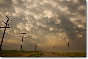
A mammatus cloud is a cloud with a unique feature which resembles
a web of pouches hanging along the base of the cloud.
In the United States, mammatus clouds tend to form in the warmer months, commonly
in the Midwest and eastern regions.
While they usually form at the bottom of a cumulonimbis cloud, they can also form
under altostratus, altocumulus, stratocumulus, and cirrus clouds. Mammatus clouds
warn that severe weather is close.
Next Topic: Nimbostratus Clouds
Current conditions powered by WeatherAPI.com


