Weather Alert in South Carolina
Flash Flood Warning issued August 22 at 5:58PM EDT until August 22 at 8:15PM EDT by NWS Charleston SC
AREAS AFFECTED: Berkeley, SC; Charleston, SC; Dorchester, SC
DESCRIPTION: At 558 PM EDT, emergency management officials reported flash flooding is still ongoing across much of the Charleston Metro Area. Many roads are reported closed and flooded across Downtown Charleston, North Charleston and surrounding communities. Radar shows bands of moderate to locally heavy rain expanding across the Metro area again. This will worsen ongoing flash flooding, especially as an elevated high tide approaches. As much as 3 to 6 inches have fallen so far today. An additional inch could fall. Tides in the Charleston Harbor are expected to reach between 7.7 and 7.9 ft MLLW, which is well into the moderate flood range. With drainage systems full of saltwater, any heavy rainfall that falls will immediately result in additional flooding. HAZARD...Life threatening flash flooding. Thunderstorms producing flash flooding. SOURCE...Emergency management reported. IMPACT...Life threatening flash flooding of creeks and streams, urban areas, highways, streets and underpasses. Some locations that will experience flash flooding include... North Charleston, Mount Pleasant, Goose Creek, Hanahan, West Ashley, Downtown Charleston, I-26/I-526 Interchange, James Island, Johns Island and Daniel Island. This includes the following highways... I-26 between mile markers 208 and 221. I-526 between mile markers 11 and 29.
INSTRUCTION: Turn around, don't drown when encountering flooded roads. Most flood deaths occur in vehicles. Report flooding directly to the Charleston National Weather Service at 1-888-383-2024 or email your reports to nws.charlestonsc@noaa.gov.
Want more detail? Get the Complete 7 Day and Night Detailed Forecast!
Current U.S. National Radar--Current
The Current National Weather Radar is shown below with a UTC Time (subtract 5 hours from UTC to get Eastern Time).

National Weather Forecast--Current
The Current National Weather Forecast and National Weather Map are shown below.

National Weather Forecast for Tomorrow
Tomorrow National Weather Forecast and Tomorrow National Weather Map are show below.

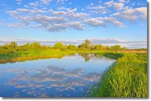
North America Water Vapor (Moisture)
This map shows recent moisture content over North America. Bright and colored areas show high moisture (ie, clouds); brown indicates very little moisture present; black indicates no moisture.

Weather Topic: What are Stratocumulus Clouds?
Home - Education - Cloud Types - Stratocumulus Clouds
 Next Topic: Stratus Clouds
Stratocumulus clouds are similar to altocumulus clouds in their
fluffy appearance, but have a slightly darker shade due to their additional mass.
A good way to distinguish the two cloud types is to hold your hand out and measure
the size of an individual cloud; if it is the size of your thumb it is generally
an altocumulus cloud, if it is the size of your hand it is generally a
stratocumulus cloud.
It is uncommon for stratocumulus clouds to produce precipitation, but if they do
it is usually a light rain or snow.
Next Topic: Stratus Clouds
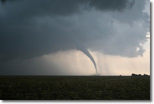
Weather Topic: What are Wall Clouds?
Home - Education - Cloud Types - Wall Clouds
 Next Topic: Altocumulus Clouds
A wall cloud forms underneath the base of a cumulonimbus cloud,
and can be a hotbed for deadly tornadoes.
Wall clouds are formed by air flowing into the cumulonimbus clouds, which can
result in the wall cloud descending from the base of the cumulonimbus cloud, or
rising fractus clouds which join to the base of the storm cloud as the wall cloud
takes shape.
Wall clouds can be very large, and in the Northern Hemisphere they generally
form at the southern edge of cumulonimbus clouds.
Next Topic: Altocumulus Clouds
Current conditions powered by WeatherAPI.com


