Weather Alert in New York
Lake Effect Snow Warning issued March 17 at 12:12PM EDT until March 18 at 8:00AM EDT by NWS Binghamton NY
AREAS AFFECTED: Northern Oneida; Southern Oneida
DESCRIPTION: * WHAT...Heavy lake effect snow expected. Total snow accumulations between 5 and 10 inches in the most persistent lake effect snow bands. Winds gusting as high as 35 mph. * WHERE...Northern Oneida and Southern Oneida Counties. * WHEN...Until 8 AM EDT Wednesday. * IMPACTS...Travel could be very difficult. The hazardous conditions could impact the Tuesday evening and Wednesday morning commutes. * ADDITIONAL DETAILS...Expect between 5 to 10 inches of snow along the Interstate 90 corridor and Mohawk Valley region of south-central Oneida County. There will be lower snowfall amounts across the far northern and southern portions of Oneida county, between 1 to 4 inches.
INSTRUCTION: If you must travel, keep an extra flashlight, food, and water in your vehicle in case of an emergency. The latest road conditions for the state you are calling from can be obtained by calling 5 1 1. During lake effect snow, the weather can vary from bands of locally heavy snow to dry weather just a few miles away. Visibilities can also vary greatly. Be prepared for rapid changes in weather, visibility, and road conditions.
Want more detail? Get the Complete 7 Day and Night Detailed Forecast!
Current U.S. National Radar--Current
The Current National Weather Radar is shown below with a UTC Time (subtract 5 hours from UTC to get Eastern Time).

National Weather Forecast--Current
The Current National Weather Forecast and National Weather Map are shown below.

National Weather Forecast for Tomorrow
Tomorrow National Weather Forecast and Tomorrow National Weather Map are show below.

North America Water Vapor (Moisture)
This map shows recent moisture content over North America. Bright and colored areas show high moisture (ie, clouds); brown indicates very little moisture present; black indicates no moisture.

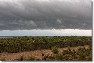
Weather Topic: What are Shelf Clouds?
Home - Education - Cloud Types - Shelf Clouds
 Next Topic: Sleet
A shelf cloud is similar to a wall cloud, but forms at the front
of a storm cloud, instead of at the rear, where wall clouds form.
A shelf cloud is caused by a series of events set into motion by the advancing
storm; first, cool air settles along the ground where precipitation has just fallen.
As the cool air is brought in, the warmer air is displaced, and rises above it,
because it is less dense. When the warmer air reaches the bottom of the storm cloud,
it begins to cool again, and the resulting condensation is a visible shelf cloud.
Next Topic: Sleet
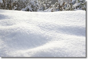
Weather Topic: What is Snow?
Home - Education - Precipitation - Snow
 Next Topic: Stratocumulus Clouds
Snow is precipitation taking the form of ice crystals. Each ice crystal, or snowflake,
has unique characteristics, but all of them grow in a hexagonal structure.
Snowfall can last for sustained periods of time and result in significant buildup
of snow on the ground.
On the earth's surface, snow starts out light and powdery, but as it begins to melt
it tends to become more granular, producing small bits of ice which have the consistency of
sand. After several cycles of melting and freezing, snow can become very dense
and ice-like, commonly known as snow pack.
Next Topic: Stratocumulus Clouds
Current conditions powered by WeatherAPI.com


