Weather Alert in Washington
Fire Weather Watch issued August 22 at 2:08PM PDT until August 26 at 9:00PM PDT by NWS Spokane WA
AREAS AFFECTED: East Washington Central Cascades; East Portion of North Cascades National Park / Lake Chelan National Recreation Area; East Washington North Cascades; Methow Valley
DESCRIPTION: ...HOT, DRY, AND UNSTABLE CONDITIONS FOR MONDAY AND TUESDAY... .A strong ridge of high pressure will bring a period of hot and dry conditions to the central and northern Cascades of Washington this weekend. The ridge will shift east of the Cascades early next week with the atmosphere becoming more unstable at that time. Increased instability with hot and dry conditions will bring the potential for critical fire weather conditions. The National Weather Service in Spokane has issued a Fire Weather Watch for hot, dry, and unstable conditions, which is in effect from Monday afternoon through Tuesday evening. * Affected Area: East Washington Central Cascades (Zone 696), East Portion of North Cascades National Park/Lake Chelan National Recreation Area (Zone 697), East Washington North Cascades (Zone 698) and Methow Valley (Zone 704). * Winds: East-Southeast 3 to 7 mph in the afternoon switching West 5 to 10 mph in the evening. * Timing: Afternoon and evening for both Monday and Tuesday. * Relative Humidities: Below 4,000 feet: 13 to 20 percent. Above 4,000 feet: 20 to 30 percent. * Temperatures: Below 4,000 feet: 90 to 102 degrees. Above 4,000 feet: 75 to 90 degrees. * Impacts: Hot, dry, and unstable conditions may lead to rapid fire growth on any new or existing fires.
INSTRUCTION: A Fire Weather Watch means that critical fire weather conditions are forecast to occur. Listen for later forecasts and possible Red Flag Warnings.
Want more detail? Get the Complete 7 Day and Night Detailed Forecast!
Current U.S. National Radar--Current
The Current National Weather Radar is shown below with a UTC Time (subtract 5 hours from UTC to get Eastern Time).

National Weather Forecast--Current
The Current National Weather Forecast and National Weather Map are shown below.

National Weather Forecast for Tomorrow
Tomorrow National Weather Forecast and Tomorrow National Weather Map are show below.

North America Water Vapor (Moisture)
This map shows recent moisture content over North America. Bright and colored areas show high moisture (ie, clouds); brown indicates very little moisture present; black indicates no moisture.

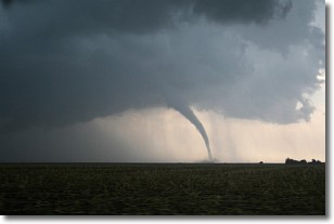
Weather Topic: What are Wall Clouds?
Home - Education - Cloud Types - Wall Clouds
 Next Topic: Altocumulus Clouds
A wall cloud forms underneath the base of a cumulonimbus cloud,
and can be a hotbed for deadly tornadoes.
Wall clouds are formed by air flowing into the cumulonimbus clouds, which can
result in the wall cloud descending from the base of the cumulonimbus cloud, or
rising fractus clouds which join to the base of the storm cloud as the wall cloud
takes shape.
Wall clouds can be very large, and in the Northern Hemisphere they generally
form at the southern edge of cumulonimbus clouds.
Next Topic: Altocumulus Clouds
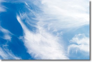
Weather Topic: What are Altostratus Clouds?
Home - Education - Cloud Types - Altostratus Clouds
 Next Topic: Cirrocumulus Clouds
Altostratus clouds form at mid to high-level altitudes
(between 2 and 7 km) and are created by a warm, stable air mass which causes
water vapor
to condense as it rise through the atmosphere. Usually altostratus clouds are
featureless sheets characterized by a uniform color.
In some cases, wind punching through the cloud formation may give it a waved
appearance, called altostratus undulatus. Altostratus clouds
are commonly seen with other cloud formations accompanying them.
Next Topic: Cirrocumulus Clouds
Current conditions powered by WeatherAPI.com


