Weather Alert in South Dakota
Wind Advisory issued September 3 at 1:10PM MDT until September 4 at 8:00PM MDT by NWS Rapid City SD
AREAS AFFECTED: Harding; Northern Perkins; Butte; Northern Meade Co Plains; Ziebach; Northern Foothills; Rapid City; Custer Co Plains; Pennington Co Plains; Haakon; Western Fall River; Northern Oglala Lakota; Northern Jackson; Bennett; Mellette; Todd; Tripp; Sturgis/Piedmont Foothills; Southern Meade Co Plains; Hermosa Foothills; Eastern Fall River; Southern Oglala Lakota; Southern Jackson; Southern Perkins
DESCRIPTION: * WHAT...Northwest winds 25 to 35 mph with gusts up to 55 mph expected. * WHERE...Portions of northwestern, south central, and southwestern South Dakota. * WHEN...From 10 AM MDT /11 AM CDT/ to 8 PM MDT /9 PM CDT/ Thursday. * IMPACTS...Sudden wind gusts can cause drivers to lose control, especially in lightweight or high profile vehicles. Strong winds can cause blowing dust, reduced visibility, and flying debris.
INSTRUCTION: Winds this strong can make driving difficult, especially for high profile vehicles. Use extra caution.
Want more detail? Get the Complete 7 Day and Night Detailed Forecast!
Current U.S. National Radar--Current
The Current National Weather Radar is shown below with a UTC Time (subtract 5 hours from UTC to get Eastern Time).

National Weather Forecast--Current
The Current National Weather Forecast and National Weather Map are shown below.

National Weather Forecast for Tomorrow
Tomorrow National Weather Forecast and Tomorrow National Weather Map are show below.

North America Water Vapor (Moisture)
This map shows recent moisture content over North America. Bright and colored areas show high moisture (ie, clouds); brown indicates very little moisture present; black indicates no moisture.

Weather Topic: What is Hail?
Home - Education - Precipitation - Hail
 Next Topic: Hole Punch Clouds
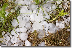
Hail is a form of precipitation which is recognized by large solid balls or
clumps of ice. Hail is created by thunderstorm clouds with strong updrafts of wind.
As the hailstones remain in the updraft, ice is deposited onto them until their
weight becomes heavy enough for them to fall to the earth's surface.
Hail storms can cause significant damage to crops, aircrafts, and man-made structures,
despite the fact that the duration is usually less than ten minutes.
Next Topic: Hole Punch Clouds
Weather Topic: What are Mammatus Clouds?
Home - Education - Cloud Types - Mammatus Clouds
 Next Topic: Nimbostratus Clouds
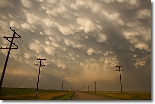
A mammatus cloud is a cloud with a unique feature which resembles
a web of pouches hanging along the base of the cloud.
In the United States, mammatus clouds tend to form in the warmer months, commonly
in the Midwest and eastern regions.
While they usually form at the bottom of a cumulonimbis cloud, they can also form
under altostratus, altocumulus, stratocumulus, and cirrus clouds. Mammatus clouds
warn that severe weather is close.
Next Topic: Nimbostratus Clouds
Current conditions powered by WeatherAPI.com


