Weather Alert in Indiana
Flood Warning issued March 6 at 9:23PM EST until March 13 at 9:12PM EDT by NWS Indianapolis IN
AREAS AFFECTED: Daviess, IN; Gibson, IN; Knox, IN; Pike, IN
DESCRIPTION: ...The Flood Warning continues for the following rivers in Indiana... Illinois... White River at Edwardsport, Spencer, Newberry, Elliston, Hazleton, and Petersburg. Wabash River at Mount Carmel. .Total rainfall amounts of 3 to over 5 inches of rain across much of central and southern Indiana is bringing widespread moderate flooding across the East Fork White and lower White basins and their tributaries. Minor flooding is expected in the lowest reach of the Wabash River at Mount Carmel starting Saturday night. Additional rainfall over the weekend and next week could lengthen the amount of time area rivers remain in flood or bring additional rises next week. * WHAT...Minor flooding is occurring and moderate flooding is forecast. * WHERE...White River at Edwardsport. * WHEN...Until Friday, March 13. * IMPACTS...At 22.9 feet, A 25 foot section of Levee Unit 8 failed at this level on March 6 2011...flooding local roads behind the levee. Flooding not nearly as bad as June 2008 levee failure. * ADDITIONAL DETAILS... - At 7:00 PM EST Friday /6:00 PM CST Friday/ the stage was 20.1 feet. - Recent Activity...The maximum river stage in the 24 hours ending at 7:00 PM EST Friday /6:00 PM CST Friday/ was 20.1 feet. - Forecast...The river is expected to rise to a crest of 22.1 feet early Monday morning. It will then fall below flood stage Friday, March 13. - Flood stage is 15.0 feet. - http://www.weather.gov/safety/flood
INSTRUCTION: Caution is urged when walking near riverbanks. Flooding is occurring or is imminent. Most flood related deaths occur in automobiles. Do not attempt to cross water covered bridges, dips, or low water crossings. Never try to cross a flowing stream, even a small one, on foot. To escape rising water find another route over higher ground. Additional information is available at www.weather.gov/ind. The next statement should be issued Saturday afternoon by around 200 PM EST /100 PM CST/.
Want more detail? Get the Complete 7 Day and Night Detailed Forecast!
Current U.S. National Radar--Current
The Current National Weather Radar is shown below with a UTC Time (subtract 5 hours from UTC to get Eastern Time).

National Weather Forecast--Current
The Current National Weather Forecast and National Weather Map are shown below.

National Weather Forecast for Tomorrow
Tomorrow National Weather Forecast and Tomorrow National Weather Map are show below.

North America Water Vapor (Moisture)
This map shows recent moisture content over North America. Bright and colored areas show high moisture (ie, clouds); brown indicates very little moisture present; black indicates no moisture.

Weather Topic: What are Stratus Clouds?
Home - Education - Cloud Types - Stratus Clouds
 Next Topic: Wall Clouds
Stratus clouds are similar to altostratus clouds, but form at a
lower altitude and are identified by their fog-like appearance, lacking the
distinguishing features of most clouds.
Stratus clouds are wider than most clouds, and their base has a smooth, uniform
look which is lighter in color than a nimbostratus cloud.
The presence of a stratus cloud indicates the possibility of minor precipitation,
such as drizzle, but heavier precipitation does not typically arrive in the form
of a stratus cloud.
Next Topic: Wall Clouds
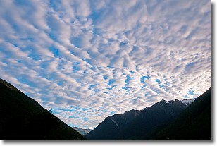
Weather Topic: What are Altocumulus Clouds?
Home - Education - Cloud Types - Altocumulus Clouds
 Next Topic: Altostratus Clouds
Similar to cirrocumulus clouds, altocumulus clouds are
characterized by cloud patches. They are distinguished by larger cloudlets
than cirrocumulus clouds but are still smaller than stratocumulus clouds.
Altocumulus clouds most commonly form in middle altitudes (between 2 and 5 km)
and may resemble, at times, the shape of a flying saucer.
These uncommon formations, called altocumulus lenticularis, are created by uplift
in the atmosphere and are most often seen in close proximity to mountains.
Next Topic: Altostratus Clouds
Current conditions powered by WeatherAPI.com


