Weather Alert in Arizona
Flood Advisory issued July 5 at 5:52PM MST until July 5 at 7:45PM MST by NWS Tucson AZ
AREAS AFFECTED: Pima, AZ
DESCRIPTION: * WHAT...Small stream flooding caused by excessive rainfall is expected. * WHERE...A portion of South Central Arizona, including the following county, central Pima. * WHEN...Until 745 PM MST. * IMPACTS...Minor flooding in low-lying and poor drainage areas. Dangerous flows over low-water crossings. * ADDITIONAL DETAILS... - At 550 PM MST, Doppler radar indicated heavy rain due to thunderstorms. This will cause small stream flooding. Between 0.5 and 1 inch of rain has fallen. - Some locations that will experience flooding include... San Isidro, Kitt Peak, Fresnal, Nolic, and Comobabi. - http://www.weather.gov/safety/flood
INSTRUCTION: Turn around, don't drown when encountering flooded roads. Most flood deaths occur in vehicles. In hilly terrain there are hundreds of low water crossings which are potentially dangerous in heavy rain. Do not attempt to cross flooded roads. Find an alternate route. Remain alert for flooding even in locations not receiving rain. Washes, streams, and rivers can become raging killer currents in a matter of minutes, even from distant rainfall.
Want more detail? Get the Complete 7 Day and Night Detailed Forecast!
Current U.S. National Radar--Current
The Current National Weather Radar is shown below with a UTC Time (subtract 5 hours from UTC to get Eastern Time).

National Weather Forecast--Current
The Current National Weather Forecast and National Weather Map are shown below.

National Weather Forecast for Tomorrow
Tomorrow National Weather Forecast and Tomorrow National Weather Map are show below.

North America Water Vapor (Moisture)
This map shows recent moisture content over North America. Bright and colored areas show high moisture (ie, clouds); brown indicates very little moisture present; black indicates no moisture.

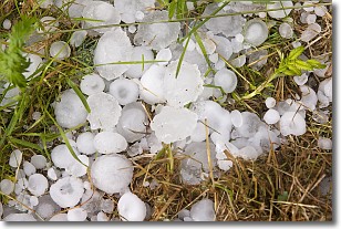
Weather Topic: What is Hail?
Home - Education - Precipitation - Hail
 Next Topic: Hole Punch Clouds
Hail is a form of precipitation which is recognized by large solid balls or
clumps of ice. Hail is created by thunderstorm clouds with strong updrafts of wind.
As the hailstones remain in the updraft, ice is deposited onto them until their
weight becomes heavy enough for them to fall to the earth's surface.
Hail storms can cause significant damage to crops, aircrafts, and man-made structures,
despite the fact that the duration is usually less than ten minutes.
Next Topic: Hole Punch Clouds
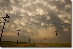
Weather Topic: What are Mammatus Clouds?
Home - Education - Cloud Types - Mammatus Clouds
 Next Topic: Nimbostratus Clouds
A mammatus cloud is a cloud with a unique feature which resembles
a web of pouches hanging along the base of the cloud.
In the United States, mammatus clouds tend to form in the warmer months, commonly
in the Midwest and eastern regions.
While they usually form at the bottom of a cumulonimbis cloud, they can also form
under altostratus, altocumulus, stratocumulus, and cirrus clouds. Mammatus clouds
warn that severe weather is close.
Next Topic: Nimbostratus Clouds
Current conditions powered by WeatherAPI.com


