Weather Alert in Hawaii
High Surf Advisory issued February 22 at 3:02PM HST until February 24 at 6:00PM HST by NWS Honolulu HI
AREAS AFFECTED: Maui Leeward West; Kohala; Molokai West; Lanai Windward
DESCRIPTION: ...HIGH SURF WARNING FOR NORTH AND EAST FACING SHORES OF NIIHAU KAUAI OAHU MOLOKAI MAUI AND BIG ISLAND FROM NOON MONDAY THROUGH TUESDAY AFTERNOON... ...HIGH SURF ADVISORY FOR WEST FACING SHORES OF MOLOKAI MAUI AND BIG ISLAND AND FOR NORTH FACING SHORES OF LANAI MONDAY NIGHT THROUGH TUESDAY... .A long period north-northeast swell will build on Monday and peak Monday night and Tuesday. This large swell from 010 to 030 degrees will produce much larger than normal surf across some coastlines, especially in windward areas. The swell will gradually decline Tuesday night through Friday. * WHAT...Along west facing shores of the Big Island in the Kohala Districts, surf building to 6 to 10 feet Monday night and Tuesday. Along west facing shores of Maui, surf building to 8 to 15 feet Monday night and Tuesday. Along west facing shores of Molokai and north facing shores of Lanai, surf building to 10 to 16 feet Monday night and Tuesday. * WHERE...West facing shores of Molokai, Maui, and Big Island and for north facing shores of Lanai. * WHEN...From 6 PM Monday to 6 PM HST Tuesday. * IMPACTS...Moderate. Strong breaking waves and strong currents will make swimming dangerous.
INSTRUCTION: Heed all advice from ocean safety officials. When in doubt, don't go out.
Want more detail? Get the Complete 7 Day and Night Detailed Forecast!
Current U.S. National Radar--Current
The Current National Weather Radar is shown below with a UTC Time (subtract 5 hours from UTC to get Eastern Time).

National Weather Forecast--Current
The Current National Weather Forecast and National Weather Map are shown below.

National Weather Forecast for Tomorrow
Tomorrow National Weather Forecast and Tomorrow National Weather Map are show below.

North America Water Vapor (Moisture)
This map shows recent moisture content over North America. Bright and colored areas show high moisture (ie, clouds); brown indicates very little moisture present; black indicates no moisture.

Weather Topic: What is Condensation?
Home - Education - Precipitation - Condensation
 Next Topic: Contrails
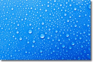
Condensation is the process which creates clouds, and therefore
it is a crucial process in the water cycle.
Condensation is the change of matter from a state of gas into a state of liquid,
and it happens because water molecules release heat into the atmosphere and
become organized into a more closely packed structure, what we might see as
water droplets.
Water is always present in the air around us as a vapor, but it's too small for
us to see. When water undergoes the process of condensation it becomes organized
into visible water droplets. You've probably seen condensation happen before on the
surface of a cold drink!
Next Topic: Contrails
Weather Topic: What are Cumulonimbus Clouds?
Home - Education - Cloud Types - Cumulonimbus Clouds
 Next Topic: Cumulus Clouds
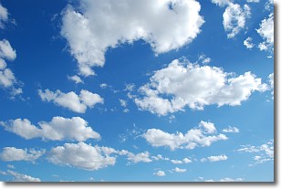
The final form taken by a growing cumulus cloud is the
cumulonimbus cloud, which is very tall and dense.
The tower of a cumulonimbus cloud can soar 23 km into the atmosphere, although
most commonly they stop growing at an altitude of 6 km.
Even small cumulonimbus clouds appear very large in comparison to other cloud types.
They can signal the approach of stormy weather, such as thunderstorms or blizzards.
Next Topic: Cumulus Clouds
Current conditions powered by WeatherAPI.com


