Weather Alert in Montana
Winter Weather Advisory issued February 22 at 8:21PM MST until February 23 at 11:00AM MST by NWS Missoula MT
AREAS AFFECTED: Kootenai/Cabinet Region
DESCRIPTION: ...WINTRY MIX IN VALLEYS AND MOUNTAIN SNOW MONDAY THROUGH MONDAY NIGHT... .Snow levels will be borderline in northwest Montana valleys, and a wintry mix brings an increased risk for slick conditions during the Monday morning commute. Confidence is highest for accumulating snow across Lincoln County valley areas. Over mountain passes, snow will begin overnight with minor impacts, intensifying by Monday afternoon. Expect moderate travel impacts with slushy accumulation on I-90 and US-2 through Monday night. * WHAT...Snow expected. There is a likelihood of minor to moderate winter weather impacts. Total snow accumulations of 1 to 3 inches on Highway 93 Eureka to Whitefish and in the Yaak, with up to 1 inch elsewhere. * WHERE...Highway 93 Eureka to Whitefish, Highway 56 Bull Lake Road, Highway 37 Eureka to Libby, and Highway 2 Kalispell to Libby. * WHEN...Until 11 AM MST Monday. * IMPACTS...For MODERATE winter weather impacts, expect disruptions to normal activities. Hazardous traveling conditions. Use extra caution while driving. Closures and disruptions to infrastructure may occur. * ADDITIONAL DETAILS...An elevated risk exists for areas of black ice on Highway 93 south of Eureka and on Highway 2 east of Libby towards Kalispell.
INSTRUCTION: Slow down and use caution while traveling. The latest road conditions for the state you are calling from can be obtained by calling 5 1 1.
Want more detail? Get the Complete 7 Day and Night Detailed Forecast!
Current U.S. National Radar--Current
The Current National Weather Radar is shown below with a UTC Time (subtract 5 hours from UTC to get Eastern Time).

National Weather Forecast--Current
The Current National Weather Forecast and National Weather Map are shown below.

National Weather Forecast for Tomorrow
Tomorrow National Weather Forecast and Tomorrow National Weather Map are show below.

North America Water Vapor (Moisture)
This map shows recent moisture content over North America. Bright and colored areas show high moisture (ie, clouds); brown indicates very little moisture present; black indicates no moisture.

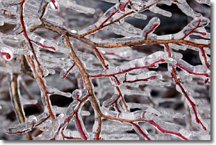
Weather Topic: What is Freezing Rain?
Home - Education - Precipitation - Freezing Rain
 Next Topic: Graupel
Freezing rain is a condition where precipitation which has fallen in the form of
water droplets reaches temperatures which are below freezing and freezes upon
coming into contact
with surface objects. The result of this precipitation is a glaze of ice which
can be damaging to plants and man-made structures. A severe onset of freezing
rain which results in a very thick glaze of ice is known as an ice storm.
Next Topic: Graupel
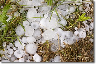
Weather Topic: What is Hail?
Home - Education - Precipitation - Hail
 Next Topic: Hole Punch Clouds
Hail is a form of precipitation which is recognized by large solid balls or
clumps of ice. Hail is created by thunderstorm clouds with strong updrafts of wind.
As the hailstones remain in the updraft, ice is deposited onto them until their
weight becomes heavy enough for them to fall to the earth's surface.
Hail storms can cause significant damage to crops, aircrafts, and man-made structures,
despite the fact that the duration is usually less than ten minutes.
Next Topic: Hole Punch Clouds
Current conditions powered by WeatherAPI.com


