Weather Alert in Maryland
Winter Weather Advisory issued February 24 at 10:36AM EST until February 25 at 10:00AM EST by NWS Baltimore MD/Washington DC
AREAS AFFECTED: Western Garrett; Eastern Garrett; Western Highland; Western Grant; Western Pendleton
DESCRIPTION: * WHAT...Snow is expected. Total snow accumulations of 3 to 5 inches; locally higher at elevations above 2500 feet. A light glaze of ice is also possible along the eastern facing ridges Wednesday morning into midday as temps warm to around freezing. Wind gusts between 35 to 45 mph; locally higher above 3500 feet. * WHERE...In Maryland, Eastern Garrett and Western Garrett Counties. In Virginia, Western Highland County. In West Virginia, Western Grant and Western Pendleton Counties. * WHEN...From 10 PM this evening to 10 AM EST Wednesday. * IMPACTS...Plan on slippery road conditions, especially along I-68/US-40 west of Frostburg, MD, WV-48 west of Moorefield, WV, US-33/WV-28 west of Franklin, WV, and US-25O west of Monterey, VA. The hazardous conditions could impact the Wednesday morning commute. Gusty winds could bring down tree branches and power-lines due to the heavier weight of the snow.
INSTRUCTION: Slow down and use caution while traveling. The latest road conditions for the state you are calling from can be obtained by calling 5 1 1.
Want more detail? Get the Complete 7 Day and Night Detailed Forecast!
Current U.S. National Radar--Current
The Current National Weather Radar is shown below with a UTC Time (subtract 5 hours from UTC to get Eastern Time).

National Weather Forecast--Current
The Current National Weather Forecast and National Weather Map are shown below.

National Weather Forecast for Tomorrow
Tomorrow National Weather Forecast and Tomorrow National Weather Map are show below.

North America Water Vapor (Moisture)
This map shows recent moisture content over North America. Bright and colored areas show high moisture (ie, clouds); brown indicates very little moisture present; black indicates no moisture.

Weather Topic: What is Snow?
Home - Education - Precipitation - Snow
 Next Topic: Stratocumulus Clouds
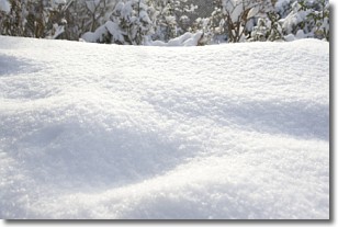
Snow is precipitation taking the form of ice crystals. Each ice crystal, or snowflake,
has unique characteristics, but all of them grow in a hexagonal structure.
Snowfall can last for sustained periods of time and result in significant buildup
of snow on the ground.
On the earth's surface, snow starts out light and powdery, but as it begins to melt
it tends to become more granular, producing small bits of ice which have the consistency of
sand. After several cycles of melting and freezing, snow can become very dense
and ice-like, commonly known as snow pack.
Next Topic: Stratocumulus Clouds
Weather Topic: What are Stratus Clouds?
Home - Education - Cloud Types - Stratus Clouds
 Next Topic: Wall Clouds
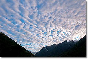
Stratus clouds are similar to altostratus clouds, but form at a
lower altitude and are identified by their fog-like appearance, lacking the
distinguishing features of most clouds.
Stratus clouds are wider than most clouds, and their base has a smooth, uniform
look which is lighter in color than a nimbostratus cloud.
The presence of a stratus cloud indicates the possibility of minor precipitation,
such as drizzle, but heavier precipitation does not typically arrive in the form
of a stratus cloud.
Next Topic: Wall Clouds
Current conditions powered by WeatherAPI.com


