Weather Alert in Wyoming
Air Quality Alert issued August 21 at 12:05PM MDT by NWS Riverton WY
AREAS AFFECTED: Southeast Bighorn Basin; Owl Creek and Bridger Mountains; Wind River Basin
DESCRIPTION: The following message is transmitted on behalf of the Wyoming Department of Environmental Quality, Air Quality Division, and the Wyoming Department of Health. * WHAT...Air Quality Alert for Wildfire Smoke. * WHERE...Portions of the Bighorn Basin, Owl Creek and Bridger Mountains, and the Wind River Basin. * WHEN...Through 1 PM Thursday, August 21. * IMPACTS...Smoke from various wildfires across the region, including the Red Canyon Fire, will continue to spread across the region today. HEALTH INFORMATION...The Wyoming Department of Health recommends that the elderly, young children, and individuals with respiratory problems avoid excessive physical exertion and minimize outdoor activities during this time. Wildfire smoke is made up of a variety of pollutants, including particulate matter and ozone, which can cause respiratory health effects. Although these people are most susceptible to health impacts, the Department of Health also advises that everyone should avoid prolonged exposure to poor air quality conditions. CURRENT CONDITIONS...The Wyoming Department of Environmental Quality, Air Quality Division offers near real-time air quality data for Wyoming's monitoring stations and health effects information to help the public interpret current conditions. Current air quality conditions across the state of Wyoming can be found at http://www.wyvisnet.com/.
INSTRUCTION: N/A
Want more detail? Get the Complete 7 Day and Night Detailed Forecast!
Current U.S. National Radar--Current
The Current National Weather Radar is shown below with a UTC Time (subtract 5 hours from UTC to get Eastern Time).

National Weather Forecast--Current
The Current National Weather Forecast and National Weather Map are shown below.

National Weather Forecast for Tomorrow
Tomorrow National Weather Forecast and Tomorrow National Weather Map are show below.

North America Water Vapor (Moisture)
This map shows recent moisture content over North America. Bright and colored areas show high moisture (ie, clouds); brown indicates very little moisture present; black indicates no moisture.

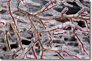
Weather Topic: What is Freezing Rain?
Home - Education - Precipitation - Freezing Rain
 Next Topic: Graupel
Freezing rain is a condition where precipitation which has fallen in the form of
water droplets reaches temperatures which are below freezing and freezes upon
coming into contact
with surface objects. The result of this precipitation is a glaze of ice which
can be damaging to plants and man-made structures. A severe onset of freezing
rain which results in a very thick glaze of ice is known as an ice storm.
Next Topic: Graupel
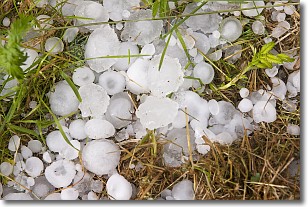
Weather Topic: What is Hail?
Home - Education - Precipitation - Hail
 Next Topic: Hole Punch Clouds
Hail is a form of precipitation which is recognized by large solid balls or
clumps of ice. Hail is created by thunderstorm clouds with strong updrafts of wind.
As the hailstones remain in the updraft, ice is deposited onto them until their
weight becomes heavy enough for them to fall to the earth's surface.
Hail storms can cause significant damage to crops, aircrafts, and man-made structures,
despite the fact that the duration is usually less than ten minutes.
Next Topic: Hole Punch Clouds
Current conditions powered by WeatherAPI.com


