Weather Alert in Maryland
Winter Storm Warning issued February 22 at 9:41PM EST until February 23 at 6:00PM EST by NWS Mount Holly NJ
AREAS AFFECTED: Kent
DESCRIPTION: ...A MAJOR WINTER STORM WILL CONTINUE TO IMPACT THE REGION THROUGH MONDAY... .A major winter storm will continue to impact the region through Monday. Very heavy snowfall and areas of blizzard conditions are expected. Moderate to heavy snowfall with rates of 1 to 2 inches per hour or more will persist overnight and into Monday morning. The heavy, wet snow will stick to trees and power lines, resulting in scattered tree damage and power outages. Record breaking snowfall totals are possible. * WHAT...Heavy snow. Additional snow accumulations between 6 and 12 inches. Winds gusting as high as 40 mph. * WHERE...Kent MD County. * WHEN...Until 6 PM EST Monday. * IMPACTS...Travel could be very difficult to impossible. Blowing snow could significantly reduce visibility. The hazardous conditions will impact the Monday morning and evening commutes. Gusty winds could bring down tree branches and result in isolated power outages. * ADDITIONAL DETAILS...Snowfall rates could exceed 2 inches per hour. Locally higher snowfall amounts possible. Blowing and drifting of snow, and whiteout conditions possible.
INSTRUCTION: If you must travel, keep an extra flashlight, food, and water in your vehicle in case of an emergency. The latest road conditions for the state you are calling from can be obtained by calling 5 1 1.
Want more detail? Get the Complete 7 Day and Night Detailed Forecast!
Current U.S. National Radar--Current
The Current National Weather Radar is shown below with a UTC Time (subtract 5 hours from UTC to get Eastern Time).

National Weather Forecast--Current
The Current National Weather Forecast and National Weather Map are shown below.

National Weather Forecast for Tomorrow
Tomorrow National Weather Forecast and Tomorrow National Weather Map are show below.

North America Water Vapor (Moisture)
This map shows recent moisture content over North America. Bright and colored areas show high moisture (ie, clouds); brown indicates very little moisture present; black indicates no moisture.

Weather Topic: What is Freezing Rain?
Home - Education - Precipitation - Freezing Rain
 Next Topic: Graupel
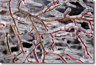
Freezing rain is a condition where precipitation which has fallen in the form of
water droplets reaches temperatures which are below freezing and freezes upon
coming into contact
with surface objects. The result of this precipitation is a glaze of ice which
can be damaging to plants and man-made structures. A severe onset of freezing
rain which results in a very thick glaze of ice is known as an ice storm.
Next Topic: Graupel
Weather Topic: What is Hail?
Home - Education - Precipitation - Hail
 Next Topic: Hole Punch Clouds
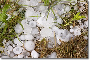
Hail is a form of precipitation which is recognized by large solid balls or
clumps of ice. Hail is created by thunderstorm clouds with strong updrafts of wind.
As the hailstones remain in the updraft, ice is deposited onto them until their
weight becomes heavy enough for them to fall to the earth's surface.
Hail storms can cause significant damage to crops, aircrafts, and man-made structures,
despite the fact that the duration is usually less than ten minutes.
Next Topic: Hole Punch Clouds
Current conditions powered by WeatherAPI.com


