Weather Alert in Montana
Winter Weather Advisory issued February 22 at 2:05PM MST until February 24 at 9:00AM MST by NWS Missoula MT
AREAS AFFECTED: Lower Clark Fork Region
DESCRIPTION: ...WINTRY MIX IN VALLEYS AND MOUNTAIN SNOW MONDAY THROUGH MONDAY NIGHT... .Snow levels will be borderline in northwest Montana valleys, and a wintry mix brings an increased risk for slick conditions during the Monday morning commute. Over mountain passes, snow will begin overnight with minor impacts, intensifying by Monday afternoon. Expect moderate travel impacts with slushy accumulation on I-90 and US-2 through Monday night. * WHAT...Snow expected. There is a likelihood of minor to moderate winter weather impacts over Lookout Pass and in the high terrain. Total snow accumulations 4 to 8 inches from Taft to Lookout Pass. * WHERE...Evaro Hill, Highway 200 Thompson Falls to Plains, I-90 Lookout Pass to Haugan, and Highway 200 Trout Creek to Heron. * WHEN...From 1 PM Monday to 9 AM MST Tuesday. * IMPACTS...For MODERATE winter weather impacts, expect disruptions to normal activities. Hazardous traveling conditions. Use extra caution while driving. Closures and disruptions to infrastructure may occur. The hazardous conditions could impact the Monday evening and Tuesday morning commutes, especially over higher passes. * ADDITIONAL DETAILS...Light pass level snow and a wintry mix in valleys may cause minor travel impacts Monday morning, but main travel impacts for Lookout Pass are expected to begin Monday afternoon.
INSTRUCTION: Slow down and use caution while traveling. The latest road conditions for the state you are calling from can be obtained by calling 5 1 1.
Want more detail? Get the Complete 7 Day and Night Detailed Forecast!
Current U.S. National Radar--Current
The Current National Weather Radar is shown below with a UTC Time (subtract 5 hours from UTC to get Eastern Time).

National Weather Forecast--Current
The Current National Weather Forecast and National Weather Map are shown below.

National Weather Forecast for Tomorrow
Tomorrow National Weather Forecast and Tomorrow National Weather Map are show below.

North America Water Vapor (Moisture)
This map shows recent moisture content over North America. Bright and colored areas show high moisture (ie, clouds); brown indicates very little moisture present; black indicates no moisture.

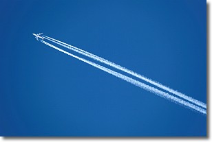
Weather Topic: What are Contrails?
Home - Education - Cloud Types - Contrails
 Next Topic: Cumulonimbus Clouds
A contrail is an artificial cloud, created by the passing of an
aircraft.
Contrails form because water vapor in the exhaust of aircraft engines is suspended
in the air under certain temperatures and humidity conditions. These contrails
are called exhaust contrails.
Another type of contrail can form due to a temporary reduction in air pressure
moving over the plane's surface, causing condensation.
These are called aerodynamic contrails.
When you can see your breath on a cold day, it is also because of condensation.
The reason contrails last longer than the condensation from your breath is
because the water in contrails freezes into ice particles.
Next Topic: Cumulonimbus Clouds
Weather Topic: What are Cumulus Clouds?
Home - Education - Cloud Types - Cumulus Clouds
 Next Topic: Drizzle
Cumulus clouds are fluffy and textured with rounded tops, and
may have flat bottoms. The border of a cumulus cloud
is clearly defined, and can have the appearance of cotton or cauliflower.
Cumulus clouds form at low altitudes (rarely above 2 km) but can grow very tall,
becoming cumulus congestus and possibly the even taller cumulonimbus clouds.
When cumulus clouds become taller, they have a greater chance of producing precipitation.
Next Topic: Drizzle
Current conditions powered by WeatherAPI.com


