Weather Alert in Washington
Flood Warning issued March 18 at 6:04AM PDT until March 21 at 9:47AM PDT by NWS Seattle WA
AREAS AFFECTED: King, WA
DESCRIPTION: ...The National Weather Service in Seattle WA has issued a Flood Warning for the following rivers in Washington... Tolt River Above Carnation affecting King County. .Heavy rain over the Central Cascades combined with high snow levels will push the Tolt Rive above Carnation above flood stage this morning. * WHAT...Minor flooding is forecast. * WHERE...Tolt River above Carnation. * WHEN...Until late Saturday morning. * IMPACTS...At 5,000.0 cfs, the Tolt River will flood Tolt River Rd NE and many driveways. Some homes in the San Souci area could be inaccessible due to deep and quick flood waters. This river level on the Tolt corresponds to a phase 3 flood in the King County flood system. * ADDITIONAL DETAILS... - At 4:15 AM PDT Wednesday the flow was 3,940.0 cfs. - Flood flow is 5,000.0 cfs. - Forecast...The river will rise above flood stage this morning to near 6400 cfs late this afternoon. It will then fall below flood stage just after midnight tonight. It will rise above flood stage again early Friday afternoon to near 5700 cfs Friday afternoon. It will then fall below flood stage again early Saturday morning. - http://www.weather.gov/safety/flood
INSTRUCTION: Turn around, don't drown when encountering flooded roads. Most flood deaths occur in vehicles. Motorists should not attempt to drive around barricades or drive cars through flooded areas. Additional information is available at www.weather.gov. The next statement will be issued by this afternoon at 215 PM PDT.
Want more detail? Get the Complete 7 Day and Night Detailed Forecast!
Current U.S. National Radar--Current
The Current National Weather Radar is shown below with a UTC Time (subtract 5 hours from UTC to get Eastern Time).

National Weather Forecast--Current
The Current National Weather Forecast and National Weather Map are shown below.

National Weather Forecast for Tomorrow
Tomorrow National Weather Forecast and Tomorrow National Weather Map are show below.

North America Water Vapor (Moisture)
This map shows recent moisture content over North America. Bright and colored areas show high moisture (ie, clouds); brown indicates very little moisture present; black indicates no moisture.

Weather Topic: What is Hail?
Home - Education - Precipitation - Hail
 Next Topic: Hole Punch Clouds
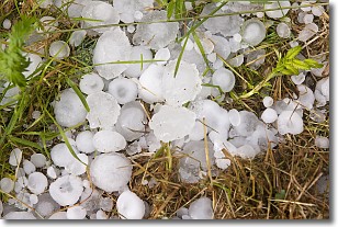
Hail is a form of precipitation which is recognized by large solid balls or
clumps of ice. Hail is created by thunderstorm clouds with strong updrafts of wind.
As the hailstones remain in the updraft, ice is deposited onto them until their
weight becomes heavy enough for them to fall to the earth's surface.
Hail storms can cause significant damage to crops, aircrafts, and man-made structures,
despite the fact that the duration is usually less than ten minutes.
Next Topic: Hole Punch Clouds
Weather Topic: What are Mammatus Clouds?
Home - Education - Cloud Types - Mammatus Clouds
 Next Topic: Nimbostratus Clouds
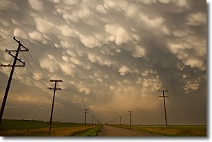
A mammatus cloud is a cloud with a unique feature which resembles
a web of pouches hanging along the base of the cloud.
In the United States, mammatus clouds tend to form in the warmer months, commonly
in the Midwest and eastern regions.
While they usually form at the bottom of a cumulonimbis cloud, they can also form
under altostratus, altocumulus, stratocumulus, and cirrus clouds. Mammatus clouds
warn that severe weather is close.
Next Topic: Nimbostratus Clouds
Current conditions powered by WeatherAPI.com


