Weather Alert in Florida
Freeze Warning Red Flag Warning Rip Current Statement
Cold Weather Advisory issued February 23 at 12:15AM EST until February 23 at 9:00AM EST by NWS Melbourne FL
AREAS AFFECTED: Inland Volusia; Northern Lake County; Orange; Seminole; Osceola; Okeechobee; Coastal Volusia; Southern Lake County; Inland Northern Brevard; Inland Indian River; Inland St. Lucie; Mainland Northern Brevard; Inland Southern Brevard
DESCRIPTION: * WHAT...For the first Cold Weather Advisory through early this morning, very cold wind chills as low as 29 expected. For the Freeze Warning Monday night into early Tuesday morning, sub-freezing temperatures as low as 31 expected. For the second Cold Weather Advisory Monday night into early Tuesday morning, very cold wind chills as low as 24 expected. * WHERE...Coastal Volusia, Inland Indian River, Inland Northern Brevard, Inland Saint Lucie, Inland Southern Brevard, Inland Volusia, Mainland Northern Brevard, Northern Lake, Okeechobee, Orange, Osceola, Seminole, and Southern Lake. * WHEN...For the first Cold Weather Advisory, until 9 AM EST this morning. For the Freeze Warning and second Cold Weather Advisory, from 2 AM to 9 AM EST Tuesday. * IMPACTS...Very cold temperatures can lead to hypothermia with prolonged exposure. Frost and freeze conditions could kill crops, other sensitive vegetation and possibly damage unprotected outdoor plumbing.
INSTRUCTION: Use caution while traveling outside. Wear appropriate clothing, a hat, and gloves. Take steps now to protect tender plants from the cold. Bring pets and potted plants indoors. Check on elderly neighbors to make sure their furnace is working. To prevent freezing and possible bursting of outdoor water pipes, they can be wrapped, drained or allowed to drip slowly.
Want more detail? Get the Complete 7 Day and Night Detailed Forecast!
Current U.S. National Radar--Current
The Current National Weather Radar is shown below with a UTC Time (subtract 5 hours from UTC to get Eastern Time).

National Weather Forecast--Current
The Current National Weather Forecast and National Weather Map are shown below.

National Weather Forecast for Tomorrow
Tomorrow National Weather Forecast and Tomorrow National Weather Map are show below.

North America Water Vapor (Moisture)
This map shows recent moisture content over North America. Bright and colored areas show high moisture (ie, clouds); brown indicates very little moisture present; black indicates no moisture.

Weather Topic: What are Shelf Clouds?
Home - Education - Cloud Types - Shelf Clouds
 Next Topic: Sleet
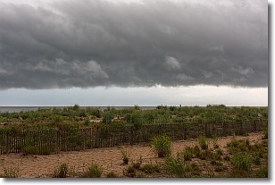
A shelf cloud is similar to a wall cloud, but forms at the front
of a storm cloud, instead of at the rear, where wall clouds form.
A shelf cloud is caused by a series of events set into motion by the advancing
storm; first, cool air settles along the ground where precipitation has just fallen.
As the cool air is brought in, the warmer air is displaced, and rises above it,
because it is less dense. When the warmer air reaches the bottom of the storm cloud,
it begins to cool again, and the resulting condensation is a visible shelf cloud.
Next Topic: Sleet
Weather Topic: What is Snow?
Home - Education - Precipitation - Snow
 Next Topic: Stratocumulus Clouds
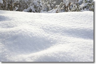
Snow is precipitation taking the form of ice crystals. Each ice crystal, or snowflake,
has unique characteristics, but all of them grow in a hexagonal structure.
Snowfall can last for sustained periods of time and result in significant buildup
of snow on the ground.
On the earth's surface, snow starts out light and powdery, but as it begins to melt
it tends to become more granular, producing small bits of ice which have the consistency of
sand. After several cycles of melting and freezing, snow can become very dense
and ice-like, commonly known as snow pack.
Next Topic: Stratocumulus Clouds
Current conditions powered by WeatherAPI.com


