Weather Alert in Florida
Rip Current Statement
Cold Weather Advisory issued February 23 at 12:15AM EST until February 24 at 9:00AM EST by NWS Melbourne FL
AREAS AFFECTED: Inland Volusia; Northern Lake County; Orange; Seminole; Osceola; Okeechobee; Coastal Volusia; Southern Lake County; Inland Northern Brevard; Inland Indian River; Inland St. Lucie; Mainland Northern Brevard; Inland Southern Brevard
DESCRIPTION: * WHAT...For the first Cold Weather Advisory through early this morning, very cold wind chills as low as 29 expected. For the Freeze Warning Monday night into early Tuesday morning, sub-freezing temperatures as low as 31 expected. For the second Cold Weather Advisory Monday night into early Tuesday morning, very cold wind chills as low as 24 expected. * WHERE...Coastal Volusia, Inland Indian River, Inland Northern Brevard, Inland Saint Lucie, Inland Southern Brevard, Inland Volusia, Mainland Northern Brevard, Northern Lake, Okeechobee, Orange, Osceola, Seminole, and Southern Lake. * WHEN...For the first Cold Weather Advisory, until 9 AM EST this morning. For the Freeze Warning and second Cold Weather Advisory, from 2 AM to 9 AM EST Tuesday. * IMPACTS...Very cold temperatures can lead to hypothermia with prolonged exposure. Frost and freeze conditions could kill crops, other sensitive vegetation and possibly damage unprotected outdoor plumbing.
INSTRUCTION: Use caution while traveling outside. Wear appropriate clothing, a hat, and gloves. Take steps now to protect tender plants from the cold. Bring pets and potted plants indoors. Check on elderly neighbors to make sure their furnace is working. To prevent freezing and possible bursting of outdoor water pipes, they can be wrapped, drained or allowed to drip slowly.
Want more detail? Get the Complete 7 Day and Night Detailed Forecast!
Current U.S. National Radar--Current
The Current National Weather Radar is shown below with a UTC Time (subtract 5 hours from UTC to get Eastern Time).

National Weather Forecast--Current
The Current National Weather Forecast and National Weather Map are shown below.

National Weather Forecast for Tomorrow
Tomorrow National Weather Forecast and Tomorrow National Weather Map are show below.

North America Water Vapor (Moisture)
This map shows recent moisture content over North America. Bright and colored areas show high moisture (ie, clouds); brown indicates very little moisture present; black indicates no moisture.

Weather Topic: What are Cumulus Clouds?
Home - Education - Cloud Types - Cumulus Clouds
 Next Topic: Drizzle
Cumulus clouds are fluffy and textured with rounded tops, and
may have flat bottoms. The border of a cumulus cloud
is clearly defined, and can have the appearance of cotton or cauliflower.
Cumulus clouds form at low altitudes (rarely above 2 km) but can grow very tall,
becoming cumulus congestus and possibly the even taller cumulonimbus clouds.
When cumulus clouds become taller, they have a greater chance of producing precipitation.
Next Topic: Drizzle
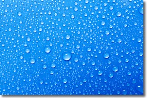
Weather Topic: What is Evaporation?
Home - Education - Precipitation - Evaporation
 Next Topic: Fog
Evaporation is the process which returns water from the earth
back to the atmosphere, and is another crucial process in the water cycle.
Evaporation is the transformation of liquid into gas, and it happens because
molecules are excited by the application of energy and turn into vapor.
In order for water to evaporate it has to be on the surface of a body of water.
Next Topic: Fog
Current conditions powered by WeatherAPI.com


