Weather Alert in Florida
Freeze Warning Red Flag Warning Rip Current Statement
Freeze Warning issued February 23 at 12:15AM EST until February 24 at 9:00AM EST by NWS Melbourne FL
AREAS AFFECTED: Inland Volusia; Northern Lake County; Orange; Seminole; Osceola; Okeechobee; Coastal Volusia; Southern Lake County; Inland Northern Brevard; Inland Indian River; Inland St. Lucie; Mainland Northern Brevard; Inland Southern Brevard
DESCRIPTION: * WHAT...For the first Cold Weather Advisory through early this morning, very cold wind chills as low as 29 expected. For the Freeze Warning Monday night into early Tuesday morning, sub-freezing temperatures as low as 31 expected. For the second Cold Weather Advisory Monday night into early Tuesday morning, very cold wind chills as low as 24 expected. * WHERE...Coastal Volusia, Inland Indian River, Inland Northern Brevard, Inland Saint Lucie, Inland Southern Brevard, Inland Volusia, Mainland Northern Brevard, Northern Lake, Okeechobee, Orange, Osceola, Seminole, and Southern Lake. * WHEN...For the first Cold Weather Advisory, until 9 AM EST this morning. For the Freeze Warning and second Cold Weather Advisory, from 2 AM to 9 AM EST Tuesday. * IMPACTS...Very cold temperatures can lead to hypothermia with prolonged exposure. Frost and freeze conditions could kill crops, other sensitive vegetation and possibly damage unprotected outdoor plumbing.
INSTRUCTION: Use caution while traveling outside. Wear appropriate clothing, a hat, and gloves. Take steps now to protect tender plants from the cold. Bring pets and potted plants indoors. Check on elderly neighbors to make sure their furnace is working. To prevent freezing and possible bursting of outdoor water pipes, they can be wrapped, drained or allowed to drip slowly.
Want more detail? Get the Complete 7 Day and Night Detailed Forecast!
Current U.S. National Radar--Current
The Current National Weather Radar is shown below with a UTC Time (subtract 5 hours from UTC to get Eastern Time).

National Weather Forecast--Current
The Current National Weather Forecast and National Weather Map are shown below.

National Weather Forecast for Tomorrow
Tomorrow National Weather Forecast and Tomorrow National Weather Map are show below.

North America Water Vapor (Moisture)
This map shows recent moisture content over North America. Bright and colored areas show high moisture (ie, clouds); brown indicates very little moisture present; black indicates no moisture.

Weather Topic: What is Rain?
Home - Education - Precipitation - Rain
 Next Topic: Shelf Clouds
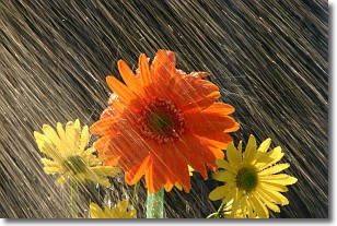
Precipitation in the form of water droplets is called rain.
Rain generally has a tendency to fall with less intensity over a greater period
of time, and when rainfall is more severe it is usually less sustained.
Rain is the most common form of precipitation and happens with greater frequency
depending on the season and regional influences. Cities have been shown to have
an observable effect on rainfall, due to an effect called the urban heat island.
Compared to upwind, monthly rainfall between twenty and forty miles downwind of
cities is 30% greater.
Next Topic: Shelf Clouds
Weather Topic: What is Sleet?
Home - Education - Precipitation - Sleet
 Next Topic: Snow
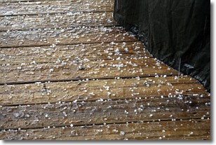
Sleet is a form of precipitation in which small ice pellets are the primary
components. These ice pellets are smaller and more translucent than hailstones,
and harder than graupel. Sleet is caused by specific atmospheric conditions and
therefore typically doesn't last for extended periods of time.
The condition which leads to sleet formation requires a warmer body of air to be
wedged in between two sub-freezing bodies of air. When snow falls through a warmer
layer of air it melts, and as it falls through the next sub-freezing body of air
it freezes again, forming ice pellets known as sleet. In some cases, water
droplets don't have time to freeze before reaching the surface and the result is
freezing rain.
Next Topic: Snow
Current conditions powered by WeatherAPI.com


