Weather Alert in Florida
Freeze Warning issued February 23 at 12:15AM EST until February 24 at 9:00AM EST by NWS Melbourne FL
AREAS AFFECTED: Inland Volusia; Northern Lake County; Orange; Seminole; Osceola; Okeechobee; Coastal Volusia; Southern Lake County; Inland Northern Brevard; Inland Indian River; Inland St. Lucie; Mainland Northern Brevard; Inland Southern Brevard
DESCRIPTION: * WHAT...For the first Cold Weather Advisory through early this morning, very cold wind chills as low as 29 expected. For the Freeze Warning Monday night into early Tuesday morning, sub-freezing temperatures as low as 31 expected. For the second Cold Weather Advisory Monday night into early Tuesday morning, very cold wind chills as low as 24 expected. * WHERE...Coastal Volusia, Inland Indian River, Inland Northern Brevard, Inland Saint Lucie, Inland Southern Brevard, Inland Volusia, Mainland Northern Brevard, Northern Lake, Okeechobee, Orange, Osceola, Seminole, and Southern Lake. * WHEN...For the first Cold Weather Advisory, until 9 AM EST this morning. For the Freeze Warning and second Cold Weather Advisory, from 2 AM to 9 AM EST Tuesday. * IMPACTS...Very cold temperatures can lead to hypothermia with prolonged exposure. Frost and freeze conditions could kill crops, other sensitive vegetation and possibly damage unprotected outdoor plumbing.
INSTRUCTION: Use caution while traveling outside. Wear appropriate clothing, a hat, and gloves. Take steps now to protect tender plants from the cold. Bring pets and potted plants indoors. Check on elderly neighbors to make sure their furnace is working. To prevent freezing and possible bursting of outdoor water pipes, they can be wrapped, drained or allowed to drip slowly.
Want more detail? Get the Complete 7 Day and Night Detailed Forecast!
Current U.S. National Radar--Current
The Current National Weather Radar is shown below with a UTC Time (subtract 5 hours from UTC to get Eastern Time).

National Weather Forecast--Current
The Current National Weather Forecast and National Weather Map are shown below.

National Weather Forecast for Tomorrow
Tomorrow National Weather Forecast and Tomorrow National Weather Map are show below.

North America Water Vapor (Moisture)
This map shows recent moisture content over North America. Bright and colored areas show high moisture (ie, clouds); brown indicates very little moisture present; black indicates no moisture.

Weather Topic: What are Altostratus Clouds?
Home - Education - Cloud Types - Altostratus Clouds
 Next Topic: Cirrocumulus Clouds
Altostratus clouds form at mid to high-level altitudes
(between 2 and 7 km) and are created by a warm, stable air mass which causes
water vapor
to condense as it rise through the atmosphere. Usually altostratus clouds are
featureless sheets characterized by a uniform color.
In some cases, wind punching through the cloud formation may give it a waved
appearance, called altostratus undulatus. Altostratus clouds
are commonly seen with other cloud formations accompanying them.
Next Topic: Cirrocumulus Clouds
Weather Topic: What are Cirrostratus Clouds?
Home - Education - Cloud Types - Cirrostratus Clouds
 Next Topic: Cirrus Clouds
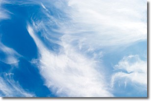
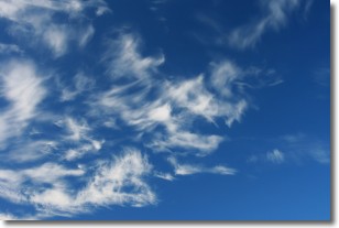
Cirrostratus clouds are high, thin clouds that form above
20,000 feet and are made mostly of ice crystals. They sometimes look like giant
feathers, horse tails, or curls of hair in the sky.
These clouds are pushed by the jet stream and can move at high speeds reaching
100 mph.
What do they indicate?
They indicate that a precipitation is likely within 24 hours.
Next Topic: Cirrus Clouds
Current conditions powered by WeatherAPI.com


