Weather Alert in Florida
Rip Current Statement
Red Flag Warning issued February 23 at 1:14AM EST until February 23 at 6:00PM EST by NWS Jacksonville FL
AREAS AFFECTED: Baker; Inland Nassau; Union; Bradford; Gilchrist; Inland Flagler; Eastern Clay; Eastern Alachua; Eastern Putnam; Coastal Flagler; Eastern Marion; Western Clay; Western Alachua; Western Putnam; Central Marion; Southeast Coastal St. Johns; Western Marion; Western Duval; Northern Inland St. Johns; Southern Inland St. Johns; Western St. Johns
DESCRIPTION: The National Weather Service in Jacksonville has issued a Red Flag Warning for critically low humidity values, strong northwesterly winds, and ongoing extreme drought conditions, which is in effect from 1 PM this afternoon to 6 PM EST this evening. The Fire Weather Watch is no longer in effect. * AFFECTED AREA...In Florida, Baker, Inland Nassau, Union, Bradford, Gilchrist, Inland Flagler, Eastern Clay, Eastern Alachua, Eastern Putnam, Coastal Flagler, Eastern Marion, Western Clay, Western Alachua, Western Putnam, Central Marion, Southeast Coastal St. Johns, Western Marion, Western Duval, Northern Inland St. Johns, Southern Inland St. Johns and Western St. Johns. * TIMING...1 PM to 6 PM Monday. * WINDS...Northwest 15 to 20 mph with gusts up to 30 mph. * RELATIVE HUMIDITY...As low as 25 percent. * TEMPERATURES...Up to 55. * IMPACTS...Ongoing wildfires will become difficult to contain and newly ignited fires may exhibit erratic fire behavior. Rapid rates of wildfire spread is expected.
INSTRUCTION: A Red Flag Warning means that critical fire weather conditions are either occurring now, or will shortly. A combination of strong winds, low relative humidity, and ongoing drought conditions can contribute to extreme fire behavior.
Want more detail? Get the Complete 7 Day and Night Detailed Forecast!
Current U.S. National Radar--Current
The Current National Weather Radar is shown below with a UTC Time (subtract 5 hours from UTC to get Eastern Time).

National Weather Forecast--Current
The Current National Weather Forecast and National Weather Map are shown below.

National Weather Forecast for Tomorrow
Tomorrow National Weather Forecast and Tomorrow National Weather Map are show below.

North America Water Vapor (Moisture)
This map shows recent moisture content over North America. Bright and colored areas show high moisture (ie, clouds); brown indicates very little moisture present; black indicates no moisture.

Weather Topic: What is Drizzle?
Home - Education - Precipitation - Drizzle
 Next Topic: Evaporation
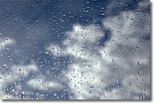
Drizzle is precipitation in the form of water droplets which are
smaller than raindrops.
Drizzle is characterized by fine, gently falling droplets and typically does not
impact human habitation in a negative way. The exception to this is freezing drizzle,
a condition where drizzle freezes immediately upon reaching earth's surface.
Freezing drizzle is still less dangerous than freezing rain, but can
potentially result in hazardous road conditions.
Next Topic: Evaporation
Weather Topic: What is Fog?
Home - Education - Cloud Types - Fog
 Next Topic: Fractus Clouds
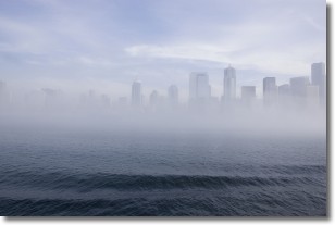
Fog is technically a type of stratus cloud, which lies along the
ground and obscures visibility.
It is usually created when humidity in the air condenses into tiny water droplets.
Because of this, some places are more prone to foggy weather, such as regions
close to a body of water.
Fog is similar to mist; both are the appearance of water droplets suspended in
the air, but fog is the term applied to the condition when visibility is less than 1 km.
Next Topic: Fractus Clouds
Current conditions powered by WeatherAPI.com


