Weather Alert in Texas
Flood Warning issued May 1 at 9:09PM CDT until May 5 at 7:00AM CDT by NWS Shreveport LA
AREAS AFFECTED: Cass, TX; Marion, TX
DESCRIPTION: ...The Flood Warning is extended for the following rivers in Texas... Little Cypress Bayou Near Jefferson affecting Marion, Upshur, Harrison and Gregg Counties. ...The Flood Warning continues for the following rivers in Texas... Black Cypress Bayou At Jefferson affecting Marion and Cass Counties. For the Black Cypress Bayou...including Jefferson...Minor flooding is forecast. For the Little Cypress Bayou...including Jefferson...Minor flooding is forecast. * WHAT...Minor flooding is forecast. * WHERE...Black Cypress Bayou at Jefferson. * WHEN...From Saturday evening to Monday morning. * IMPACTS...At 13.0 feet, Lowland flooding will affect mainly timber resources. * ADDITIONAL DETAILS... - At 8:00 PM CDT Thursday the stage was 11.3 feet. - Bankfull stage is 13.0 feet. - Forecast...The river is expected to rise to a crest of 13.0 feet Saturday evening. It will then fall below flood stage early Sunday afternoon. - Flood stage is 13.0 feet. - http://www.weather.gov/safety/flood
INSTRUCTION: Do not drive cars through flooded areas. Caution is urged when walking near riverbanks. Turn around, don't drown when encountering flooded roads. Most flood deaths occur in vehicles. Motorists should not attempt to drive around barricades or drive cars through flooded areas. For more hydrologic information, copy and paste the following website address into your favorite web browser URL bar: https://water.noaa.gov/wfo/SHV The next statement will be issued Friday evening at 915 PM CDT.
Want more detail? Get the Complete 7 Day and Night Detailed Forecast!
Current U.S. National Radar--Current
The Current National Weather Radar is shown below with a UTC Time (subtract 5 hours from UTC to get Eastern Time).

National Weather Forecast--Current
The Current National Weather Forecast and National Weather Map are shown below.

National Weather Forecast for Tomorrow
Tomorrow National Weather Forecast and Tomorrow National Weather Map are show below.

North America Water Vapor (Moisture)
This map shows recent moisture content over North America. Bright and colored areas show high moisture (ie, clouds); brown indicates very little moisture present; black indicates no moisture.

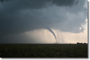
Weather Topic: What are Wall Clouds?
Home - Education - Cloud Types - Wall Clouds
 Next Topic: Altocumulus Clouds
A wall cloud forms underneath the base of a cumulonimbus cloud,
and can be a hotbed for deadly tornadoes.
Wall clouds are formed by air flowing into the cumulonimbus clouds, which can
result in the wall cloud descending from the base of the cumulonimbus cloud, or
rising fractus clouds which join to the base of the storm cloud as the wall cloud
takes shape.
Wall clouds can be very large, and in the Northern Hemisphere they generally
form at the southern edge of cumulonimbus clouds.
Next Topic: Altocumulus Clouds
Weather Topic: What are Altostratus Clouds?
Home - Education - Cloud Types - Altostratus Clouds
 Next Topic: Cirrocumulus Clouds
Altostratus clouds form at mid to high-level altitudes
(between 2 and 7 km) and are created by a warm, stable air mass which causes
water vapor
to condense as it rise through the atmosphere. Usually altostratus clouds are
featureless sheets characterized by a uniform color.
In some cases, wind punching through the cloud formation may give it a waved
appearance, called altostratus undulatus. Altostratus clouds
are commonly seen with other cloud formations accompanying them.
Next Topic: Cirrocumulus Clouds
Current conditions powered by WeatherAPI.com


