Weather Alert in Maryland
Coastal Flood Advisory issued August 23 at 2:10PM EDT until August 25 at 6:00AM EDT by NWS Baltimore MD/Washington DC
AREAS AFFECTED: Southern Baltimore; Calvert; Southeast Harford
DESCRIPTION: * WHAT...One and a half of two feet of inundation above ground level in low lying areas due to tidal flooding. * WHERE...Southern Baltimore, Calvert and Southeast Harford Counties. * WHEN...Until 6 AM EDT Monday, especially around the time of high tide. * IMPACTS...At 3.5 feet, flooding is occurring at the end of Thames Street in Baltimore. Water covers the promenade in the Inner Harbor in multiple locations. At 3.0 feet, water begins encroaching upon yards in the Bowleys Quarters area. At 4.5 feet, portions of the Havre de Grace Yacht Basin are flooded, along with Hutchins Park. At 3.0 feet, water is expected to reach backyards near 9th Street in North Beach, and could approach 9th Street. At 3.0 feet, parking lots near Charles Street in Solomons begin to flood, with several inches of water covering low-lying portions of Charles Street and Williams Street. * ADDITIONAL DETAILS...Tides two to two and a half feet above normal. The next high tide at Chesapeake Beach is at 4:53 PM and 5:24 AM. The next high tide at Havre de Grace is at 11:02 PM and 11:10 AM. The next high tide at Solomons Island is at 3:04 PM and 3:36 AM. The next high tide at Fort McHenry Baltimore is at 7:40 PM and 8:11 AM.
INSTRUCTION: If travel is required, allow extra time as some roads may be closed. Do not drive around barricades or through water of unknown depth. Take the necessary actions to protect flood-prone property.
Want more detail? Get the Complete 7 Day and Night Detailed Forecast!
Current U.S. National Radar--Current
The Current National Weather Radar is shown below with a UTC Time (subtract 5 hours from UTC to get Eastern Time).

National Weather Forecast--Current
The Current National Weather Forecast and National Weather Map are shown below.

National Weather Forecast for Tomorrow
Tomorrow National Weather Forecast and Tomorrow National Weather Map are show below.

North America Water Vapor (Moisture)
This map shows recent moisture content over North America. Bright and colored areas show high moisture (ie, clouds); brown indicates very little moisture present; black indicates no moisture.

Weather Topic: What is Drizzle?
Home - Education - Precipitation - Drizzle
 Next Topic: Evaporation
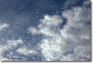
Drizzle is precipitation in the form of water droplets which are
smaller than raindrops.
Drizzle is characterized by fine, gently falling droplets and typically does not
impact human habitation in a negative way. The exception to this is freezing drizzle,
a condition where drizzle freezes immediately upon reaching earth's surface.
Freezing drizzle is still less dangerous than freezing rain, but can
potentially result in hazardous road conditions.
Next Topic: Evaporation
Weather Topic: What is Fog?
Home - Education - Cloud Types - Fog
 Next Topic: Fractus Clouds
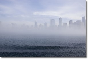
Fog is technically a type of stratus cloud, which lies along the
ground and obscures visibility.
It is usually created when humidity in the air condenses into tiny water droplets.
Because of this, some places are more prone to foggy weather, such as regions
close to a body of water.
Fog is similar to mist; both are the appearance of water droplets suspended in
the air, but fog is the term applied to the condition when visibility is less than 1 km.
Next Topic: Fractus Clouds
Current conditions powered by WeatherAPI.com


