Weather Alert in Alaska
Flood Advisory issued September 5 at 11:59AM AKDT until September 6 at 12:00PM AKDT by NWS Fairbanks AK
AREAS AFFECTED: Upper Koyukuk Valley
DESCRIPTION: * WHAT...Flooding caused by excessive rainfall continues. * WHERE...Koyukuk River near Allakaket. * WHEN...Until noon AKDT Saturday. * IMPACTS...Minor flooding in low-lying and poorly drained areas. * ADDITIONAL DETAILS... - As of Friday morning, there have been reports of some low lying roads being inundated. - The streamgage on the Koyukuk River below the John River shows water levels have been fluctuating less that a foot over the last 5 days and are not showing a significant rising or dropping trend. Additional rain accumulations of 0.5 to 1.0 inches is expected Saturday afternoon through Sunday which is expected to keep water levels steady at Allakaket for the next few days. - Http://www.weather.gov/aprfc
INSTRUCTION: Stay tuned to further developments by listening to your local radio, television, or NOAA Weather Radio for further information.
Want more detail? Get the Complete 7 Day and Night Detailed Forecast!
Current U.S. National Radar--Current
The Current National Weather Radar is shown below with a UTC Time (subtract 5 hours from UTC to get Eastern Time).

National Weather Forecast--Current
The Current National Weather Forecast and National Weather Map are shown below.

National Weather Forecast for Tomorrow
Tomorrow National Weather Forecast and Tomorrow National Weather Map are show below.

North America Water Vapor (Moisture)
This map shows recent moisture content over North America. Bright and colored areas show high moisture (ie, clouds); brown indicates very little moisture present; black indicates no moisture.

Weather Topic: What are Cirrus Clouds?
Home - Education - Cloud Types - Cirrus Clouds
 Next Topic: Condensation
Cirrus clouds are high-level clouds that occur above 20,000 feet
and are composed mainly of ice crystals.
They are thin and wispy in appearance.
What do they indicate?
They are often the first sign of an approaching storm.
Next Topic: Condensation
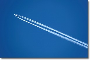
Weather Topic: What are Contrails?
Home - Education - Cloud Types - Contrails
 Next Topic: Cumulonimbus Clouds
A contrail is an artificial cloud, created by the passing of an
aircraft.
Contrails form because water vapor in the exhaust of aircraft engines is suspended
in the air under certain temperatures and humidity conditions. These contrails
are called exhaust contrails.
Another type of contrail can form due to a temporary reduction in air pressure
moving over the plane's surface, causing condensation.
These are called aerodynamic contrails.
When you can see your breath on a cold day, it is also because of condensation.
The reason contrails last longer than the condensation from your breath is
because the water in contrails freezes into ice particles.
Next Topic: Cumulonimbus Clouds
Current conditions powered by WeatherAPI.com


