Weather Alert in Idaho
Heat Advisory issued September 1 at 11:40AM PDT until September 4 at 8:00PM PDT by NWS Spokane WA
AREAS AFFECTED: Coeur d'Alene Area; Upper Columbia Basin; Spokane Area; Waterville Plateau
DESCRIPTION: * WHAT...Hot temperatures. High temperatures 95 to 103 degrees. Limited overnight relief with low temperatures 60 to 70 degrees. * WHERE...Grand Coulee, Airway Heights, Hayden, Spokane Valley, Davenport, Fairfield, Post Falls, Creston, Worley, Badger Mountain Road, Downtown Spokane, Coeur d'Alene, Ritzville, Wilbur, Coulee City, Rockford, Mansfield, Odessa, Harrington, Waterville, and Cheney. * WHEN...Until 8 PM PDT Thursday. * IMPACTS...Hot temperatures will increase the risk of heat-related illnesses. Heat Risk of this magnitude impacts almost everyone who does not have access to adequate cooling or hydration.
INSTRUCTION: Drink plenty of fluids, stay in an air-conditioned room, stay out of the sun, and check up on relatives and neighbors. Take extra precautions when outside. Wear lightweight and loose fitting clothing. Try to limit strenuous activities to early morning or evening. Take action when you see symptoms of heat exhaustion and heat stroke. Heat stroke is an emergency! Call 9-1-1 if you see someone exhibiting heat stroke symptoms.
Want more detail? Get the Complete 7 Day and Night Detailed Forecast!
Current U.S. National Radar--Current
The Current National Weather Radar is shown below with a UTC Time (subtract 5 hours from UTC to get Eastern Time).

National Weather Forecast--Current
The Current National Weather Forecast and National Weather Map are shown below.

National Weather Forecast for Tomorrow
Tomorrow National Weather Forecast and Tomorrow National Weather Map are show below.

North America Water Vapor (Moisture)
This map shows recent moisture content over North America. Bright and colored areas show high moisture (ie, clouds); brown indicates very little moisture present; black indicates no moisture.

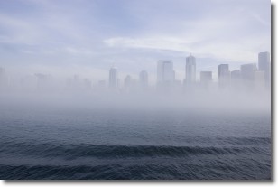
Weather Topic: What is Fog?
Home - Education - Cloud Types - Fog
 Next Topic: Fractus Clouds
Fog is technically a type of stratus cloud, which lies along the
ground and obscures visibility.
It is usually created when humidity in the air condenses into tiny water droplets.
Because of this, some places are more prone to foggy weather, such as regions
close to a body of water.
Fog is similar to mist; both are the appearance of water droplets suspended in
the air, but fog is the term applied to the condition when visibility is less than 1 km.
Next Topic: Fractus Clouds
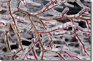
Weather Topic: What is Freezing Rain?
Home - Education - Precipitation - Freezing Rain
 Next Topic: Graupel
Freezing rain is a condition where precipitation which has fallen in the form of
water droplets reaches temperatures which are below freezing and freezes upon
coming into contact
with surface objects. The result of this precipitation is a glaze of ice which
can be damaging to plants and man-made structures. A severe onset of freezing
rain which results in a very thick glaze of ice is known as an ice storm.
Next Topic: Graupel
Current conditions powered by WeatherAPI.com


