Weather Alert in Alaska
Flood Watch issued August 26 at 3:49PM AKDT until August 28 at 10:00AM AKDT by NWS Anchorage AK
AREAS AFFECTED: Kuskokwim Valley West; Kuskokwim Valley East; Interior Kuskokwim Delta; Western Capes; Northern Bristol Bay Coast; Inland Bristol Bay
DESCRIPTION: * WHAT...Flooding caused by excessive rainfall continues to be possible. * WHERE...Interior Kuskokwim Delta, Kuskokwim Valley, Northern Bristol Bay Coast, Inland Bristol Bay, and Western Capes. * WHEN...Through Thursday morning. * IMPACTS...Excessive runoff may result in flooding of small streams and other low-lying and flood-prone locations. Significant ponding of water, areal flooding, and erosion may occur in poor drainage areas. Flooding is not expected along the main Kuskokwim River and other major rivers. * ADDITIONAL DETAILS... - About 0.5 to 1 inches of rain have fallen since Monday, with some areas receiving 1.5 inches or more. An additional 1 to 2.5 inches of rain are forecast through Thursday from the front currently moving through Southwest Alaska, and from a North Pacific storm arriving later on Wednesday. There is still uncertainty with the track of the storm on Wednesday, and whether rain from this storm will spread west to Bethel or remain east of Dillingham. As such, confidence is low to medium regarding forecast rain amounts. - Http://www.weather.gov/safety/flood
INSTRUCTION: You should monitor later forecasts and be alert for possible Flood Warnings. Those living in areas prone to flooding should be prepared to take action should flooding develop.
Want more detail? Get the Complete 7 Day and Night Detailed Forecast!
Current U.S. National Radar--Current
The Current National Weather Radar is shown below with a UTC Time (subtract 5 hours from UTC to get Eastern Time).

National Weather Forecast--Current
The Current National Weather Forecast and National Weather Map are shown below.

National Weather Forecast for Tomorrow
Tomorrow National Weather Forecast and Tomorrow National Weather Map are show below.

North America Water Vapor (Moisture)
This map shows recent moisture content over North America. Bright and colored areas show high moisture (ie, clouds); brown indicates very little moisture present; black indicates no moisture.

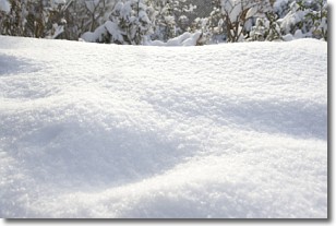
Weather Topic: What is Snow?
Home - Education - Precipitation - Snow
 Next Topic: Stratocumulus Clouds
Snow is precipitation taking the form of ice crystals. Each ice crystal, or snowflake,
has unique characteristics, but all of them grow in a hexagonal structure.
Snowfall can last for sustained periods of time and result in significant buildup
of snow on the ground.
On the earth's surface, snow starts out light and powdery, but as it begins to melt
it tends to become more granular, producing small bits of ice which have the consistency of
sand. After several cycles of melting and freezing, snow can become very dense
and ice-like, commonly known as snow pack.
Next Topic: Stratocumulus Clouds
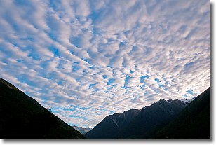
Weather Topic: What are Stratus Clouds?
Home - Education - Cloud Types - Stratus Clouds
 Next Topic: Wall Clouds
Stratus clouds are similar to altostratus clouds, but form at a
lower altitude and are identified by their fog-like appearance, lacking the
distinguishing features of most clouds.
Stratus clouds are wider than most clouds, and their base has a smooth, uniform
look which is lighter in color than a nimbostratus cloud.
The presence of a stratus cloud indicates the possibility of minor precipitation,
such as drizzle, but heavier precipitation does not typically arrive in the form
of a stratus cloud.
Next Topic: Wall Clouds
Current conditions powered by WeatherAPI.com


