Weather Alert in South Dakota
Red Flag Warning issued February 26 at 10:04PM MST until February 27 at 6:00PM MST by NWS Rapid City SD
AREAS AFFECTED: Bennett County Area; Mellette and Todd Counties
DESCRIPTION: ...RED FLAG WARNING IN EFFECT FROM NOON MST/100 PM CST TO 600 PM MST/700 PM CST FRIDAY FOR GUSTY WINDS AND LOW RELATIVE HUMIDITY FOR FIRE WEATHER ZONES 315, 317, 322, 326, 333, 334, AND 335... .Very dry air will affect parts of northeastern Wyoming as well as far southwestern into south-central South Dakota Friday afternoon. Minimum relative humidities will drop to 15 to 20 percent as northwest winds blow at 10 to 25 mph with gusts from 25 to 40 mph, strongest over south-central South Dakota. Antecedent D1 to D2 drought conditions will exacerbate the fire potential. The combination of low humidity values and gusty winds will create critical fire weather conditions on Friday for these areas. The National Weather Service in Rapid City has issued a Red Flag Warning for gusty winds and low relative humidity, which is in effect from noon MST /1 PM CST/ to 6 PM MST /7 PM CST/ Friday. * AFFECTED AREA...Fire Weather Zones 333 Bennett County Area and 334 Mellette and Todd Counties. * WINDS...Northwest 15 to 25 mph with gusts up to 30 mph. * RELATIVE HUMIDITY...As low as 15 to 18 percent. * IMPACTS...The combination of gusty winds and low relative humidity would produce critical fire weather conditions.
INSTRUCTION: A Red Flag Warning means that critical fire weather conditions are either occurring now, or will shortly. A combination of strong winds, low relative humidity, and warm temperatures can contribute to extreme fire behavior.
Want more detail? Get the Complete 7 Day and Night Detailed Forecast!
Current U.S. National Radar--Current
The Current National Weather Radar is shown below with a UTC Time (subtract 5 hours from UTC to get Eastern Time).

National Weather Forecast--Current
The Current National Weather Forecast and National Weather Map are shown below.

National Weather Forecast for Tomorrow
Tomorrow National Weather Forecast and Tomorrow National Weather Map are show below.

North America Water Vapor (Moisture)
This map shows recent moisture content over North America. Bright and colored areas show high moisture (ie, clouds); brown indicates very little moisture present; black indicates no moisture.

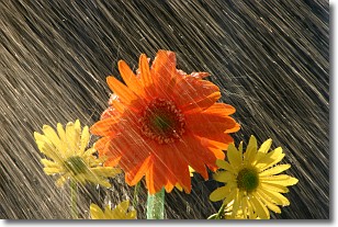
Weather Topic: What is Precipitation?
Home - Education - Precipitation - Precipitation
 Next Topic: Rain
Precipitation can refer to many different forms of water that
may fall from clouds. Precipitation occurs after a cloud has become saturated to
the point where its water particles are more dense than the air below the cloud.
In most cases, precipitation will reach the ground, but it is not uncommon for
precipitation to evaporate before it reaches the earth's surface.
When precipitation evaporates before it contacts the ground it is called Virga.
Graupel, hail, sleet, rain, drizzle, and snow are forms of precipitation, but fog
and mist are not considered precipitation because the water vapor which
constitutes them isn't dense enough to fall to the ground.
Next Topic: Rain
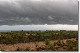
Weather Topic: What are Shelf Clouds?
Home - Education - Cloud Types - Shelf Clouds
 Next Topic: Sleet
A shelf cloud is similar to a wall cloud, but forms at the front
of a storm cloud, instead of at the rear, where wall clouds form.
A shelf cloud is caused by a series of events set into motion by the advancing
storm; first, cool air settles along the ground where precipitation has just fallen.
As the cool air is brought in, the warmer air is displaced, and rises above it,
because it is less dense. When the warmer air reaches the bottom of the storm cloud,
it begins to cool again, and the resulting condensation is a visible shelf cloud.
Next Topic: Sleet
Current conditions powered by WeatherAPI.com


