Weather Alert in South Dakota
Red Flag Warning issued February 26 at 10:04PM MST until February 27 at 6:00PM MST by NWS Rapid City SD
AREAS AFFECTED: Fall River County Area
DESCRIPTION: ...RED FLAG WARNING IN EFFECT FROM NOON MST/100 PM CST TO 600 PM MST/700 PM CST FRIDAY FOR GUSTY WINDS AND LOW RELATIVE HUMIDITY FOR FIRE WEATHER ZONES 315, 317, 322, 326, 333, 334, AND 335... .Very dry air will affect parts of northeastern Wyoming as well as far southwestern into south-central South Dakota Friday afternoon. Minimum relative humidities will drop to 15 to 20 percent as northwest winds blow at 10 to 25 mph with gusts from 25 to 40 mph, strongest over south-central South Dakota. Antecedent D1 to D2 drought conditions will exacerbate the fire potential. The combination of low humidity values and gusty winds will create critical fire weather conditions on Friday for these areas. The National Weather Service in Rapid City has issued a Red Flag Warning for gusty winds and low relative humidity, which is in effect from noon to 6 PM MST Friday. The Fire Weather Watch is no longer in effect. * AFFECTED AREA...Fire Weather Zone 322 Fall River County Area. * WINDS...Northwest 10 to 20 mph with gusts up to 30 mph. * RELATIVE HUMIDITY...As low as 15 percent. * IMPACTS...The combination of gusty winds and low relative humidity would produce critical fire weather conditions.
INSTRUCTION: A Red Flag Warning means that critical fire weather conditions are either occurring now, or will shortly. A combination of strong winds, low relative humidity, and warm temperatures can contribute to extreme fire behavior.
Want more detail? Get the Complete 7 Day and Night Detailed Forecast!
Current U.S. National Radar--Current
The Current National Weather Radar is shown below with a UTC Time (subtract 5 hours from UTC to get Eastern Time).

National Weather Forecast--Current
The Current National Weather Forecast and National Weather Map are shown below.

National Weather Forecast for Tomorrow
Tomorrow National Weather Forecast and Tomorrow National Weather Map are show below.

North America Water Vapor (Moisture)
This map shows recent moisture content over North America. Bright and colored areas show high moisture (ie, clouds); brown indicates very little moisture present; black indicates no moisture.

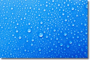
Weather Topic: What is Condensation?
Home - Education - Precipitation - Condensation
 Next Topic: Contrails
Condensation is the process which creates clouds, and therefore
it is a crucial process in the water cycle.
Condensation is the change of matter from a state of gas into a state of liquid,
and it happens because water molecules release heat into the atmosphere and
become organized into a more closely packed structure, what we might see as
water droplets.
Water is always present in the air around us as a vapor, but it's too small for
us to see. When water undergoes the process of condensation it becomes organized
into visible water droplets. You've probably seen condensation happen before on the
surface of a cold drink!
Next Topic: Contrails
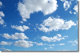
Weather Topic: What are Cumulonimbus Clouds?
Home - Education - Cloud Types - Cumulonimbus Clouds
 Next Topic: Cumulus Clouds
The final form taken by a growing cumulus cloud is the
cumulonimbus cloud, which is very tall and dense.
The tower of a cumulonimbus cloud can soar 23 km into the atmosphere, although
most commonly they stop growing at an altitude of 6 km.
Even small cumulonimbus clouds appear very large in comparison to other cloud types.
They can signal the approach of stormy weather, such as thunderstorms or blizzards.
Next Topic: Cumulus Clouds
Current conditions powered by WeatherAPI.com


