Weather Alert in Montana
Avalanche Watch issued February 22 at 6:19PM MST by NWS Missoula MT
AREAS AFFECTED: West Glacier Region
DESCRIPTION: AVAMSO The following message is transmitted at the request of the Flathead Avalanche Center Hungry Horse MT ...The Flathead Avalanche Center Hungry Horse MT has issued a Backcountry Avalanche Watch... * WHAT...An incoming storm may create exceptionally dangerous conditions. * WHERE...Flathead Range, Whitefish Range, Swan Range, and Apgar Ranges, and the Lake McDonald Valley and Marias Pass regions in Glacier National Park. * WHEN...In effect until 12 PM MST Monday * IMPACTS...If snow and strong winds arrive Monday as forecast, avalanche danger may rise to High (Level 4 of 5). New and drifted snow will overload a snowpack already producing large and very large avalanches. Many slides are being triggered from long distances away in lower-angle terrain below, near, and above steep slopes. The likelihood of natural and human- triggered avalanches will increase.
INSTRUCTION: Exceptionally dangerous avalanche conditions may develop. Travel in avalanche terrain is not recommended. Avalanches may run long distances and can run into mature forests, valley floors, or flat terrain. Consult http://www.flatheadavalanche.org for more detailed information. Similar avalanche danger may exist at locations outside the coverage area of any Avalanche Center.
Want more detail? Get the Complete 7 Day and Night Detailed Forecast!
Current U.S. National Radar--Current
The Current National Weather Radar is shown below with a UTC Time (subtract 5 hours from UTC to get Eastern Time).

National Weather Forecast--Current
The Current National Weather Forecast and National Weather Map are shown below.

National Weather Forecast for Tomorrow
Tomorrow National Weather Forecast and Tomorrow National Weather Map are show below.

North America Water Vapor (Moisture)
This map shows recent moisture content over North America. Bright and colored areas show high moisture (ie, clouds); brown indicates very little moisture present; black indicates no moisture.

Weather Topic: What are Altostratus Clouds?
Home - Education - Cloud Types - Altostratus Clouds
 Next Topic: Cirrocumulus Clouds
Altostratus clouds form at mid to high-level altitudes
(between 2 and 7 km) and are created by a warm, stable air mass which causes
water vapor
to condense as it rise through the atmosphere. Usually altostratus clouds are
featureless sheets characterized by a uniform color.
In some cases, wind punching through the cloud formation may give it a waved
appearance, called altostratus undulatus. Altostratus clouds
are commonly seen with other cloud formations accompanying them.
Next Topic: Cirrocumulus Clouds
Weather Topic: What are Cirrostratus Clouds?
Home - Education - Cloud Types - Cirrostratus Clouds
 Next Topic: Cirrus Clouds
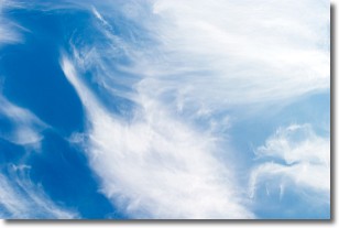
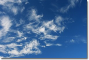
Cirrostratus clouds are high, thin clouds that form above
20,000 feet and are made mostly of ice crystals. They sometimes look like giant
feathers, horse tails, or curls of hair in the sky.
These clouds are pushed by the jet stream and can move at high speeds reaching
100 mph.
What do they indicate?
They indicate that a precipitation is likely within 24 hours.
Next Topic: Cirrus Clouds
Current conditions powered by WeatherAPI.com


