Weather Alert in Montana
Avalanche Watch issued February 22 at 6:19PM MST by NWS Missoula MT
AREAS AFFECTED: West Glacier Region
DESCRIPTION: AVAMSO The following message is transmitted at the request of the Flathead Avalanche Center Hungry Horse MT ...The Flathead Avalanche Center Hungry Horse MT has issued a Backcountry Avalanche Watch... * WHAT...An incoming storm may create exceptionally dangerous conditions. * WHERE...Flathead Range, Whitefish Range, Swan Range, and Apgar Ranges, and the Lake McDonald Valley and Marias Pass regions in Glacier National Park. * WHEN...In effect until 12 PM MST Monday * IMPACTS...If snow and strong winds arrive Monday as forecast, avalanche danger may rise to High (Level 4 of 5). New and drifted snow will overload a snowpack already producing large and very large avalanches. Many slides are being triggered from long distances away in lower-angle terrain below, near, and above steep slopes. The likelihood of natural and human- triggered avalanches will increase.
INSTRUCTION: Exceptionally dangerous avalanche conditions may develop. Travel in avalanche terrain is not recommended. Avalanches may run long distances and can run into mature forests, valley floors, or flat terrain. Consult http://www.flatheadavalanche.org for more detailed information. Similar avalanche danger may exist at locations outside the coverage area of any Avalanche Center.
Want more detail? Get the Complete 7 Day and Night Detailed Forecast!
Current U.S. National Radar--Current
The Current National Weather Radar is shown below with a UTC Time (subtract 5 hours from UTC to get Eastern Time).

National Weather Forecast--Current
The Current National Weather Forecast and National Weather Map are shown below.

National Weather Forecast for Tomorrow
Tomorrow National Weather Forecast and Tomorrow National Weather Map are show below.

North America Water Vapor (Moisture)
This map shows recent moisture content over North America. Bright and colored areas show high moisture (ie, clouds); brown indicates very little moisture present; black indicates no moisture.

Weather Topic: What is Hail?
Home - Education - Precipitation - Hail
 Next Topic: Hole Punch Clouds
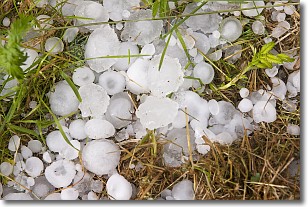
Hail is a form of precipitation which is recognized by large solid balls or
clumps of ice. Hail is created by thunderstorm clouds with strong updrafts of wind.
As the hailstones remain in the updraft, ice is deposited onto them until their
weight becomes heavy enough for them to fall to the earth's surface.
Hail storms can cause significant damage to crops, aircrafts, and man-made structures,
despite the fact that the duration is usually less than ten minutes.
Next Topic: Hole Punch Clouds
Weather Topic: What are Mammatus Clouds?
Home - Education - Cloud Types - Mammatus Clouds
 Next Topic: Nimbostratus Clouds
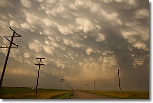
A mammatus cloud is a cloud with a unique feature which resembles
a web of pouches hanging along the base of the cloud.
In the United States, mammatus clouds tend to form in the warmer months, commonly
in the Midwest and eastern regions.
While they usually form at the bottom of a cumulonimbis cloud, they can also form
under altostratus, altocumulus, stratocumulus, and cirrus clouds. Mammatus clouds
warn that severe weather is close.
Next Topic: Nimbostratus Clouds
Current conditions powered by WeatherAPI.com


