Weather Alert in Arizona
Extreme Heat Warning issued August 22 at 12:30PM MST until August 24 at 8:00PM MST by NWS Tucson AZ
AREAS AFFECTED: Tucson Metro Area including Tucson/Green Valley/Marana/Vail; South Central Pinal County including Eloy/Picacho Peak State Park; Southeast Pinal County including Kearny/Mammoth/Oracle
DESCRIPTION: * WHAT...Dangerously hot conditions with temperatures up to 105 across eastern Pima county and southeastern Pinal county leading to Major Heat Risk. * WHERE...South Central Pinal County, Southeast Pinal County, and Tucson Metro Area. * WHEN...Until 8 PM MST Sunday. * IMPACTS...Heat related illnesses increase significantly during extreme heat events. * ADDITIONAL DETAILS...Major Heat Risk is when heat will affect anyone without cooling or hydration as well as health systems and industries.
INSTRUCTION: To reduce risk during outdoor work, the Occupational Safety and Health Administration recommends scheduling frequent rest breaks in shaded or air conditioned environments. Anyone overcome by heat should be moved to a cool and shaded location. Heat stroke is an emergency! Call 9 1 1. Take extra precautions if you work or spend time outside. When possible, reschedule strenuous activities to early morning or evening. Know the signs and symptoms of heat exhaustion and heat stroke. Wear lightweight and loose fitting clothing when possible and drink plenty of water.
Want more detail? Get the Complete 7 Day and Night Detailed Forecast!
Current U.S. National Radar--Current
The Current National Weather Radar is shown below with a UTC Time (subtract 5 hours from UTC to get Eastern Time).

National Weather Forecast--Current
The Current National Weather Forecast and National Weather Map are shown below.

National Weather Forecast for Tomorrow
Tomorrow National Weather Forecast and Tomorrow National Weather Map are show below.

North America Water Vapor (Moisture)
This map shows recent moisture content over North America. Bright and colored areas show high moisture (ie, clouds); brown indicates very little moisture present; black indicates no moisture.

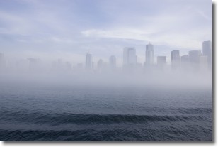
Weather Topic: What is Fog?
Home - Education - Cloud Types - Fog
 Next Topic: Fractus Clouds
Fog is technically a type of stratus cloud, which lies along the
ground and obscures visibility.
It is usually created when humidity in the air condenses into tiny water droplets.
Because of this, some places are more prone to foggy weather, such as regions
close to a body of water.
Fog is similar to mist; both are the appearance of water droplets suspended in
the air, but fog is the term applied to the condition when visibility is less than 1 km.
Next Topic: Fractus Clouds
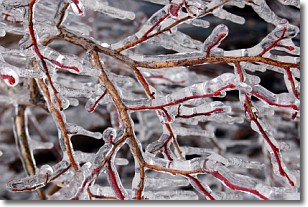
Weather Topic: What is Freezing Rain?
Home - Education - Precipitation - Freezing Rain
 Next Topic: Graupel
Freezing rain is a condition where precipitation which has fallen in the form of
water droplets reaches temperatures which are below freezing and freezes upon
coming into contact
with surface objects. The result of this precipitation is a glaze of ice which
can be damaging to plants and man-made structures. A severe onset of freezing
rain which results in a very thick glaze of ice is known as an ice storm.
Next Topic: Graupel
Current conditions powered by WeatherAPI.com


