Weather Alert in Georgia
Flood Watch issued August 23 at 2:33AM EDT until August 24 at 2:00AM EDT by NWS Charleston SC
AREAS AFFECTED: Jenkins; Screven; Candler; Bulloch; Effingham; Tattnall; Evans; Inland Bryan; Coastal Bryan; Inland Chatham; Coastal Chatham; Long; Inland Liberty; Coastal Liberty; Inland McIntosh; Coastal McIntosh; Allendale; Hampton; Inland Colleton; Dorchester; Inland Berkeley; Inland Jasper; Beaufort; Coastal Colleton; Charleston; Coastal Jasper; Tidal Berkeley
DESCRIPTION: * WHAT...Flash flooding caused by excessive rainfall continues to be possible. * WHERE...Portions of southeast Georgia, including the following areas, Bulloch, Candler, Coastal Bryan, Coastal Chatham, Coastal Liberty, Coastal McIntosh, Effingham, Evans, Inland Bryan, Inland Chatham, Inland Liberty, Inland McIntosh, Jenkins, Long, Screven and Tattnall and southeast South Carolina, including the following areas, Allendale, Beaufort, Charleston, Coastal Colleton, Coastal Jasper, Dorchester, Hampton, Inland Berkeley, Inland Colleton, Inland Jasper and Tidal Berkeley. * WHEN...Through late tonight. * IMPACTS...Excessive runoff may result in flooding of rivers, creeks, streams, and other low-lying and flood-prone locations. Creeks and streams may rise out of their banks. Flooding may occur in poor drainage and urban areas. Storm drains and ditches may become clogged with debris. Extensive street flooding and flooding of creeks and rivers are possible. * ADDITIONAL DETAILS... - Showers and thunderstorms produced numerous areas of 3 to 5 inches, with localized areas receiving in excess of 7 inches, of rainfall on Friday across southeast Georgia and the South Carolina. An additional 1.5 to 2.5 inches of rainfall can be expected across the region through this evening. The heaviest rainfall should occur generally along and east of the Interstate 95 corridor, some areas possibly receiving in excess of 4 inches. The additional rainfall falling on nearly saturated soil will likely lead to rapid runoff, possibly producing flash flooding. Several streams and creeks have elevated water levels following the heavy rainfall that occurred on Friday. Based on the forecast rainfall, Church Creek near West Ashley, French Quarter Creek near Huger, and Ireland Creek at Waterboro could see water levels crest above flood stage. In addition, flash flooding may develop within coastal cities with any heavy downpours that coincide with high tide this morning or this evening. - http://www.weather.gov/safety/flood
INSTRUCTION: Be prepared to protect life and property, especially in areas prone to flooding. If flooding develops, move to higher ground immediately. If driving, be prepared for flooded roadways and possible road closures.
Want more detail? Get the Complete 7 Day and Night Detailed Forecast!
Current U.S. National Radar--Current
The Current National Weather Radar is shown below with a UTC Time (subtract 5 hours from UTC to get Eastern Time).

National Weather Forecast--Current
The Current National Weather Forecast and National Weather Map are shown below.

National Weather Forecast for Tomorrow
Tomorrow National Weather Forecast and Tomorrow National Weather Map are show below.

North America Water Vapor (Moisture)
This map shows recent moisture content over North America. Bright and colored areas show high moisture (ie, clouds); brown indicates very little moisture present; black indicates no moisture.

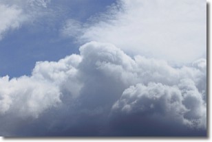
Weather Topic: What are Nimbostratus Clouds?
Home - Education - Cloud Types - Nimbostratus Clouds
 Next Topic: Precipitation
A nimbostratus cloud is similar to a stratus cloud in its formless,
smooth appearance. However, a nimbostratus cloud is darker than a stratus cloud,
because it is thicker.
Unlike a stratus cloud, a nimbostratus cloud typically brings with it the threat
of moderate to heavy precipitation. In some cases, the precipitation may evaporate
before reaching the ground, a phenomenon known as virga.
Next Topic: Precipitation
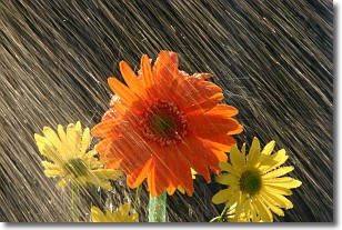
Weather Topic: What is Rain?
Home - Education - Precipitation - Rain
 Next Topic: Shelf Clouds
Precipitation in the form of water droplets is called rain.
Rain generally has a tendency to fall with less intensity over a greater period
of time, and when rainfall is more severe it is usually less sustained.
Rain is the most common form of precipitation and happens with greater frequency
depending on the season and regional influences. Cities have been shown to have
an observable effect on rainfall, due to an effect called the urban heat island.
Compared to upwind, monthly rainfall between twenty and forty miles downwind of
cities is 30% greater.
Next Topic: Shelf Clouds
Current conditions powered by WeatherAPI.com


