Weather Alert in Kentucky
Flood Watch issued March 3 at 10:39AM EST until March 4 at 1:00PM EST by NWS Charleston WV
AREAS AFFECTED: Greenup; Carter; Boyd; Lawrence; Perry; Morgan; Athens; Washington; Jackson; Vinton; Meigs; Gallia; Lawrence; Wayne; Cabell; Mason; Jackson; Wood; Pleasants; Tyler; Lincoln; Putnam; Kanawha; Roane; Wirt; Calhoun; Ritchie; Doddridge; Boone; Clay; Braxton; Gilmer; Lewis; Harrison; Taylor; Upshur; Barbour; Northwest Fayette; Southeast Fayette; Northwest Nicholas; Southeast Nicholas; Northwest Webster; Southeast Webster; Northwest Pocahontas; Southeast Pocahontas; Northwest Randolph; Southeast Randolph
DESCRIPTION: * WHAT...Flooding caused by excessive rainfall is possible. * WHERE...Portions of northeast Kentucky, including the following counties, Boyd, Carter, Greenup and Lawrence, southeast Ohio, including the following counties, Athens, Gallia, Jackson OH, Lawrence OH, Meigs, Morgan, Perry, Vinton and Washington, and West Virginia, including the following counties, Barbour, Boone, Braxton, Cabell, Calhoun, Clay, Doddridge, Gilmer, Harrison, Jackson WV, Kanawha, Lewis, Lincoln, Mason, Northwest Fayette, Northwest Nicholas, Northwest Pocahontas, Northwest Randolph, Northwest Webster, Pleasants, Putnam, Ritchie, Roane, Southeast Fayette, Southeast Nicholas, Southeast Pocahontas, Southeast Randolph, Southeast Webster, Taylor, Tyler, Upshur, Wayne, Wirt and Wood. * WHEN...Through Wednesday afternoon. * IMPACTS...Excessive runoff may result in flooding of rivers, creeks, streams, and other low-lying and flood-prone locations. Creeks and streams may rise out of their banks. * ADDITIONAL DETAILS... - Isolated flash flooding is also possible. 1 to 2 inches of rain is expected in the watch area through Wednesday afternoon. - http://www.weather.gov/safety/flood
INSTRUCTION: You should monitor later forecasts and be alert for possible Flood Warnings. Those living in areas prone to flooding should be prepared to take action should flooding develop. Additional information can be found at https://www.weather.gov/rlx as well as on our X and Facebook pages.
Want more detail? Get the Complete 7 Day and Night Detailed Forecast!
Current U.S. National Radar--Current
The Current National Weather Radar is shown below with a UTC Time (subtract 5 hours from UTC to get Eastern Time).

National Weather Forecast--Current
The Current National Weather Forecast and National Weather Map are shown below.

National Weather Forecast for Tomorrow
Tomorrow National Weather Forecast and Tomorrow National Weather Map are show below.

North America Water Vapor (Moisture)
This map shows recent moisture content over North America. Bright and colored areas show high moisture (ie, clouds); brown indicates very little moisture present; black indicates no moisture.

Weather Topic: What are Contrails?
Home - Education - Cloud Types - Contrails
 Next Topic: Cumulonimbus Clouds
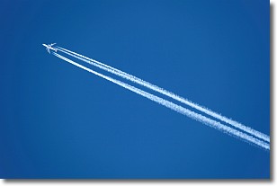
A contrail is an artificial cloud, created by the passing of an
aircraft.
Contrails form because water vapor in the exhaust of aircraft engines is suspended
in the air under certain temperatures and humidity conditions. These contrails
are called exhaust contrails.
Another type of contrail can form due to a temporary reduction in air pressure
moving over the plane's surface, causing condensation.
These are called aerodynamic contrails.
When you can see your breath on a cold day, it is also because of condensation.
The reason contrails last longer than the condensation from your breath is
because the water in contrails freezes into ice particles.
Next Topic: Cumulonimbus Clouds
Weather Topic: What are Cumulus Clouds?
Home - Education - Cloud Types - Cumulus Clouds
 Next Topic: Drizzle
Cumulus clouds are fluffy and textured with rounded tops, and
may have flat bottoms. The border of a cumulus cloud
is clearly defined, and can have the appearance of cotton or cauliflower.
Cumulus clouds form at low altitudes (rarely above 2 km) but can grow very tall,
becoming cumulus congestus and possibly the even taller cumulonimbus clouds.
When cumulus clouds become taller, they have a greater chance of producing precipitation.
Next Topic: Drizzle
Current conditions powered by WeatherAPI.com


