Weather Alert in Washington
Avalanche Warning issued March 17 at 7:30PM PDT by NWS Seattle WA
AREAS AFFECTED: Cascades of Whatcom and Skagit Counties; Cascades of Snohomish and Northern King Counties
DESCRIPTION: AVWSEW The following message is transmitted at the request of the Northwest Avalanche Center. ...The Northwest Avalanche Center in Seattle has issued an Avalanche Warning... * WHAT...High avalanche danger is expected in the West Central zone Tuesday night and Wednesday. * WHERE...The West Central Zone is along the West Slopes of the Cascades from SR20 to north of I-90. It includes the Mountain Loop Highway and the mountains near and south of Hwy 2 along the West Slopes of the Cascades. Dangerous avalanche conditions are expected in neighboring zones. * WHEN...In effect from Tue 18:30 PDT to Wed 18:30 PDT. * IMPACTS...Large to very large natural wet snow avalanches are expected. Avalanches that release from higher elevations could run long distances to lower elevations or into terrain that is usually considered safe. * PRECAUTIONARY / PREPAREDNESS ACTIONS...Very dangerous avalanche conditions are expected. Travel in backcountry terrain is not recommended. Put a large buffer between you and terrain where avalanches can start, run, and stop. Consult https://www.nwac.us/ or www.avalanche.org for more detailed information. Similar avalanche danger may exist at locations outside the coverage area of this or any avalanche center. D'Amico
INSTRUCTION: N/A
Want more detail? Get the Complete 7 Day and Night Detailed Forecast!
Current U.S. National Radar--Current
The Current National Weather Radar is shown below with a UTC Time (subtract 5 hours from UTC to get Eastern Time).

National Weather Forecast--Current
The Current National Weather Forecast and National Weather Map are shown below.

National Weather Forecast for Tomorrow
Tomorrow National Weather Forecast and Tomorrow National Weather Map are show below.

North America Water Vapor (Moisture)
This map shows recent moisture content over North America. Bright and colored areas show high moisture (ie, clouds); brown indicates very little moisture present; black indicates no moisture.

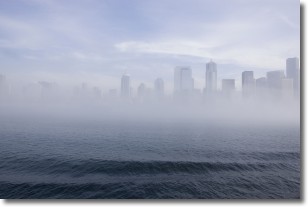
Weather Topic: What is Fog?
Home - Education - Cloud Types - Fog
 Next Topic: Fractus Clouds
Fog is technically a type of stratus cloud, which lies along the
ground and obscures visibility.
It is usually created when humidity in the air condenses into tiny water droplets.
Because of this, some places are more prone to foggy weather, such as regions
close to a body of water.
Fog is similar to mist; both are the appearance of water droplets suspended in
the air, but fog is the term applied to the condition when visibility is less than 1 km.
Next Topic: Fractus Clouds
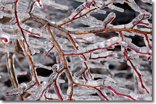
Weather Topic: What is Freezing Rain?
Home - Education - Precipitation - Freezing Rain
 Next Topic: Graupel
Freezing rain is a condition where precipitation which has fallen in the form of
water droplets reaches temperatures which are below freezing and freezes upon
coming into contact
with surface objects. The result of this precipitation is a glaze of ice which
can be damaging to plants and man-made structures. A severe onset of freezing
rain which results in a very thick glaze of ice is known as an ice storm.
Next Topic: Graupel
Current conditions powered by WeatherAPI.com


