Weather Alert in Alaska
Winter Storm Warning issued March 2 at 9:37PM AKST until March 4 at 12:00PM AKST by NWS Juneau AK
AREAS AFFECTED: Glacier Bay; Eastern Chichagof Island; Cape Fairweather to Lisianski Strait; City and Borough of Juneau
DESCRIPTION: ...MULTIPLE ROUNDS OF SNOWFALL EXPECTED THROUGH MIDWEEK... Light snow will continue tonight along the Icy Strait corridor south to Sumner Strait, with an additional 1 to 2 inches possible. Another system moving into the panhandle tonight will bring heavier snowfall rates across much of central and northern southeast Alaska. Snow is expected to mix with and eventually change over to rain on Tuesday from Sitka over to Kake and Petersburg, however, if the changeover is delayed, snowfall amounts could be higher. * WHAT...Heavy snow expected. Total snow accumulations of 10 to 13 inches. Winds gusting as high as 40 mph. * WHERE...Glacier Bay, Eastern Chichagof Island, Cape Fairweather to Lisianski Strait and City and Borough of Juneau. * WHEN...From 3 AM Tuesday to noon AKST Wednesday. * IMPACTS...Travel will be very difficult and is discouraged unless it is an emergency. The hazardous conditions could impact the morning or evening commute. * ADDITIONAL DETAILS...Heaviest snowfall rates are expected Tuesday afternoon into Wednesday morning, with snowfall rates of an inch an hour possible.
INSTRUCTION: If you must travel, keep an extra flashlight, food, and water with you in case of an emergency. People are urged to prepare their property before the onset of winter weather. For the latest road conditions, where available, call 5 1 1 or visit 511.alaska.gov.
Want more detail? Get the Complete 7 Day and Night Detailed Forecast!
Current U.S. National Radar--Current
The Current National Weather Radar is shown below with a UTC Time (subtract 5 hours from UTC to get Eastern Time).

National Weather Forecast--Current
The Current National Weather Forecast and National Weather Map are shown below.

National Weather Forecast for Tomorrow
Tomorrow National Weather Forecast and Tomorrow National Weather Map are show below.

North America Water Vapor (Moisture)
This map shows recent moisture content over North America. Bright and colored areas show high moisture (ie, clouds); brown indicates very little moisture present; black indicates no moisture.

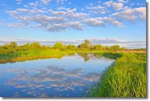
Weather Topic: What are Stratocumulus Clouds?
Home - Education - Cloud Types - Stratocumulus Clouds
 Next Topic: Stratus Clouds
Stratocumulus clouds are similar to altocumulus clouds in their
fluffy appearance, but have a slightly darker shade due to their additional mass.
A good way to distinguish the two cloud types is to hold your hand out and measure
the size of an individual cloud; if it is the size of your thumb it is generally
an altocumulus cloud, if it is the size of your hand it is generally a
stratocumulus cloud.
It is uncommon for stratocumulus clouds to produce precipitation, but if they do
it is usually a light rain or snow.
Next Topic: Stratus Clouds
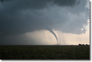
Weather Topic: What are Wall Clouds?
Home - Education - Cloud Types - Wall Clouds
 Next Topic: Altocumulus Clouds
A wall cloud forms underneath the base of a cumulonimbus cloud,
and can be a hotbed for deadly tornadoes.
Wall clouds are formed by air flowing into the cumulonimbus clouds, which can
result in the wall cloud descending from the base of the cumulonimbus cloud, or
rising fractus clouds which join to the base of the storm cloud as the wall cloud
takes shape.
Wall clouds can be very large, and in the Northern Hemisphere they generally
form at the southern edge of cumulonimbus clouds.
Next Topic: Altocumulus Clouds
Current conditions powered by WeatherAPI.com


