Weather Alert in New York
Lake Effect Snow Warning issued March 18 at 12:30AM EDT until March 18 at 8:00AM EDT by NWS Binghamton NY
AREAS AFFECTED: Onondaga; Madison
DESCRIPTION: * WHAT...Heavy lake effect snow. Additional snow accumulations up to 7 inches. * WHERE...Madison and Onondaga Counties. * WHEN...Until 8 AM EDT this morning. * IMPACTS...Plan on slippery road conditions. The hazardous conditions could impact the Wednesday morning commute. * ADDITIONAL DETAILS...Expect 5 to 10 inches of snow just north of Interstate 90, with much lower amounts of 1 to 3 inches south. Localized snowfall rates of 1 to 2 inches per hour at times will be possible. The snow quickly tapers off to scattered snow showers and flurries Wednesday morning. The highest snowfall amounts are expected in the Lakeport, Bridgeport, Clay, Cicero and Brewerton area. The City of Syracuse is forecast to see only 1 to 3 inches of snow.
INSTRUCTION: If you must travel, keep an extra flashlight, food, and water in your vehicle in case of an emergency. The latest road conditions for the state you are calling from can be obtained by calling 5 1 1. During lake effect snow, the weather can vary from bands of locally heavy snow to dry weather just a few miles away. Visibilities can also vary greatly. Be prepared for rapid changes in weather, visibility, and road conditions.
Want more detail? Get the Complete 7 Day and Night Detailed Forecast!
Current U.S. National Radar--Current
The Current National Weather Radar is shown below with a UTC Time (subtract 5 hours from UTC to get Eastern Time).

National Weather Forecast--Current
The Current National Weather Forecast and National Weather Map are shown below.

National Weather Forecast for Tomorrow
Tomorrow National Weather Forecast and Tomorrow National Weather Map are show below.

North America Water Vapor (Moisture)
This map shows recent moisture content over North America. Bright and colored areas show high moisture (ie, clouds); brown indicates very little moisture present; black indicates no moisture.

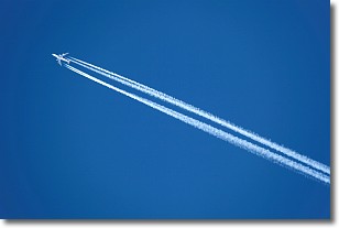
Weather Topic: What are Contrails?
Home - Education - Cloud Types - Contrails
 Next Topic: Cumulonimbus Clouds
A contrail is an artificial cloud, created by the passing of an
aircraft.
Contrails form because water vapor in the exhaust of aircraft engines is suspended
in the air under certain temperatures and humidity conditions. These contrails
are called exhaust contrails.
Another type of contrail can form due to a temporary reduction in air pressure
moving over the plane's surface, causing condensation.
These are called aerodynamic contrails.
When you can see your breath on a cold day, it is also because of condensation.
The reason contrails last longer than the condensation from your breath is
because the water in contrails freezes into ice particles.
Next Topic: Cumulonimbus Clouds
Weather Topic: What are Cumulus Clouds?
Home - Education - Cloud Types - Cumulus Clouds
 Next Topic: Drizzle
Cumulus clouds are fluffy and textured with rounded tops, and
may have flat bottoms. The border of a cumulus cloud
is clearly defined, and can have the appearance of cotton or cauliflower.
Cumulus clouds form at low altitudes (rarely above 2 km) but can grow very tall,
becoming cumulus congestus and possibly the even taller cumulonimbus clouds.
When cumulus clouds become taller, they have a greater chance of producing precipitation.
Next Topic: Drizzle
Current conditions powered by WeatherAPI.com


