Weather Alert in Indiana
Beach Hazards Statement issued August 23 at 9:12AM EDT until August 26 at 8:00PM EDT by NWS Northern Indiana
AREAS AFFECTED: Northern La Porte; Northern Berrien; Southern Berrien
DESCRIPTION: * WHAT...Waves 2 to 4 feet today building to 3 to 5 feet on Sunday through Tuesday. High wave action, strong currents, and dangerous swimming conditions expected. Piers will be heavily swamped by waves. * WHERE...In Indiana, Northern La Porte county. In Michigan, Northern Berrien and Southern Berrien counties. * WHEN...Through Tuesday evening. * IMPACTS...Strong currents can pull swimmers into deeper water and high waves can sweep people off piers.
INSTRUCTION: Remain out of the water to avoid hazardous swimming conditions. Do not venture out on piers. Wear a life vest when on or around the water.
Want more detail? Get the Complete 7 Day and Night Detailed Forecast!
Current U.S. National Radar--Current
The Current National Weather Radar is shown below with a UTC Time (subtract 5 hours from UTC to get Eastern Time).

National Weather Forecast--Current
The Current National Weather Forecast and National Weather Map are shown below.

National Weather Forecast for Tomorrow
Tomorrow National Weather Forecast and Tomorrow National Weather Map are show below.

North America Water Vapor (Moisture)
This map shows recent moisture content over North America. Bright and colored areas show high moisture (ie, clouds); brown indicates very little moisture present; black indicates no moisture.

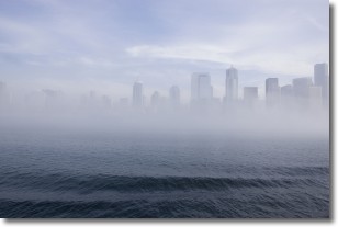
Weather Topic: What is Fog?
Home - Education - Cloud Types - Fog
 Next Topic: Fractus Clouds
Fog is technically a type of stratus cloud, which lies along the
ground and obscures visibility.
It is usually created when humidity in the air condenses into tiny water droplets.
Because of this, some places are more prone to foggy weather, such as regions
close to a body of water.
Fog is similar to mist; both are the appearance of water droplets suspended in
the air, but fog is the term applied to the condition when visibility is less than 1 km.
Next Topic: Fractus Clouds
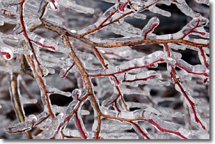
Weather Topic: What is Freezing Rain?
Home - Education - Precipitation - Freezing Rain
 Next Topic: Graupel
Freezing rain is a condition where precipitation which has fallen in the form of
water droplets reaches temperatures which are below freezing and freezes upon
coming into contact
with surface objects. The result of this precipitation is a glaze of ice which
can be damaging to plants and man-made structures. A severe onset of freezing
rain which results in a very thick glaze of ice is known as an ice storm.
Next Topic: Graupel
Current conditions powered by WeatherAPI.com


