Weather Alert in Oregon
Air Quality Alert issued August 22 at 10:49AM PDT by NWS Portland OR
AREAS AFFECTED: Tualatin Valley; West Hills and Chehalem Mountains; Inner Portland Metro; East Portland Metro; West Central Willamette Valley; East Central Willamette Valley; Benton County Lowlands; Linn County Lowlands; Lane County Lowlands
DESCRIPTION: The Oregon Department of Environmental Quality, and the Lane Regional Air Protection Agency has issued an Air Quality Advisory, which is IN EFFECT FROM 10 AM SATURDAY TO 8 PM PDT MONDAY. An Air Quality Advisory for Ozone has been issued. High levels of ozone in the lower atmosphere in the region combined with forecasted conditions will cause air quality to reach unhealthy levels at times through Monday evening. Pollutants can cause burning eyes, runny nose, aggravate heart and lung diseases, and aggravate other serious health problems. Limit outdoor activities and keep children indoors. Please follow medical advice if you have a heart or lung condition. More information about air quality can be found at: www.orcaa.org www.swcleanair.gov www.oregon.gov/DEQ www.lrapa.org
INSTRUCTION: N/A
Want more detail? Get the Complete 7 Day and Night Detailed Forecast!
Current U.S. National Radar--Current
The Current National Weather Radar is shown below with a UTC Time (subtract 5 hours from UTC to get Eastern Time).

National Weather Forecast--Current
The Current National Weather Forecast and National Weather Map are shown below.

National Weather Forecast for Tomorrow
Tomorrow National Weather Forecast and Tomorrow National Weather Map are show below.

North America Water Vapor (Moisture)
This map shows recent moisture content over North America. Bright and colored areas show high moisture (ie, clouds); brown indicates very little moisture present; black indicates no moisture.

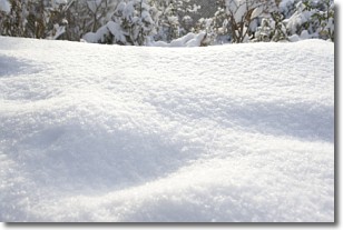
Weather Topic: What is Snow?
Home - Education - Precipitation - Snow
 Next Topic: Stratocumulus Clouds
Snow is precipitation taking the form of ice crystals. Each ice crystal, or snowflake,
has unique characteristics, but all of them grow in a hexagonal structure.
Snowfall can last for sustained periods of time and result in significant buildup
of snow on the ground.
On the earth's surface, snow starts out light and powdery, but as it begins to melt
it tends to become more granular, producing small bits of ice which have the consistency of
sand. After several cycles of melting and freezing, snow can become very dense
and ice-like, commonly known as snow pack.
Next Topic: Stratocumulus Clouds
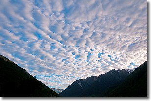
Weather Topic: What are Stratus Clouds?
Home - Education - Cloud Types - Stratus Clouds
 Next Topic: Wall Clouds
Stratus clouds are similar to altostratus clouds, but form at a
lower altitude and are identified by their fog-like appearance, lacking the
distinguishing features of most clouds.
Stratus clouds are wider than most clouds, and their base has a smooth, uniform
look which is lighter in color than a nimbostratus cloud.
The presence of a stratus cloud indicates the possibility of minor precipitation,
such as drizzle, but heavier precipitation does not typically arrive in the form
of a stratus cloud.
Next Topic: Wall Clouds
Current conditions powered by WeatherAPI.com


